Traffic data: The key to effective road traffic management
&w=256&q=90)
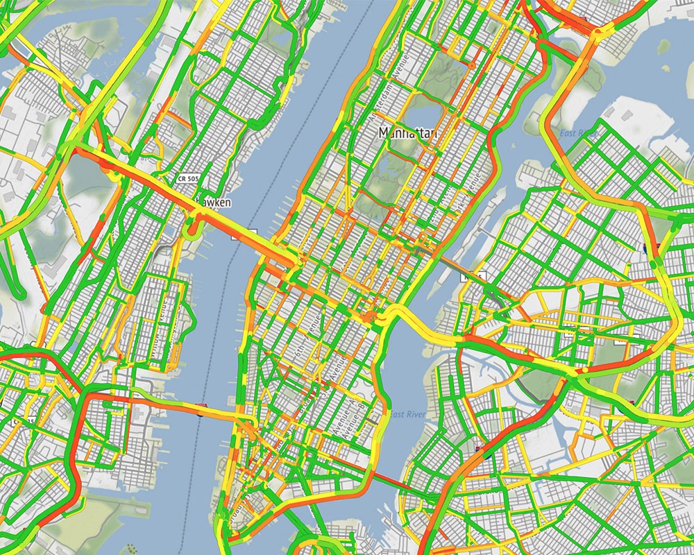
Floating car data (FCD) is commonly used to derive historic travel times on individual roads, as well as evaluate traffic data algorithms. FCD, which is GPS data obtained from navigation devices and applications, provides a vehicle’s location and speed to feed live automated traffic management systems with essential information.
With a market share of 80% of real-time traffic services for automotive navigation in Europe alone, TomTom is the global leader in traffic and live services. With over 600 million drivers in 81 countries using our connected navigation, we are increasing road safety and making the roads less congested for all.
By being able to predict traffic, offer accurate arrival time information and find the best route for each journey, TomTom Traffic and Live Services cater to drivers, automakers, governments and technology companies across the world. For public authorities in particular, knowing how to influence traffic in order to ensure viable traffic flows and the efficient use of the infrastructure is critical. Traffic is connected to transport, commerce and a healthy economy, and using location technology is game-changer for how people move around their cities.
A checklist for your traffic management plan
If you are a road authority that needs to create an efficient traffic management plan, here are eight elements to consider – and check off your list.
Travel time reliability
Road operators work to attain stable travel times and road service levels so drivers on their network always know what to expect. An effective way to do this is by performing reliability studies.
By using the aggregated statistics provided by TomTom, operators can perform studies for any location. The floating car traffic data (FCD) - an archive with actual journeys taken by road users with TomTom devices - covers the entire road network, so operators can do an analysis wherever needed.
The great benefit of this type of travel-time based analysis, compared to Bluetooth or ANPR statistics, is that it is location independent, covers all parts of the road network, and lacks the financial and safety risks posed by the actual placement and maintenance of such technology.
Using historical traffic data to solve traffic bottlenecks
By comparing the travel times during peak hours with those under free-flowing traffic conditions, traffic data can be used to identify congestion hotspots throughout the road network. It is also possible to compare hotspots, or bottlenecks, with each other and formulate actions and policies to reduce delays.
For example, road authorities can use information about delays at intersections to prioritize signal retiming or changes to lane configurations. Traffic circulation changes can also help reduce or eliminate bottlenecks.
The use of FCD in this type of analysis makes it possible to assess all road categories throughout the entire road network. As TomTom archives FCD data, operators can perform this type of analysis retrospectively.
Traffic management for public transportation
Traffic management is not only about road network traffic. Users of public transport are a key part of the wider transportation network and demand a comfortable and stable mobility service.
By analyzing locations or corridors where travel times are slow due to congestion, authorities can make decisions about busways or signal priority based on solid data.
Traffic management for urban logistics and road infrastructure
Public authorities are continually evaluating alternatives for improving road infrastructure. In cases where management alone cannot optimize the existing capacity of roads, authorities often make investments to expand the capacity. Historical data can support the decision-making process and evaluate the return on investment by providing:
Travel times and speeds on the road and the surrounding network both before and after the new infrastructure was built.
Origin-destination travel flows to help predict what trips will be influenced by the change in infrastructure.
Input to travel forecasting and simulation models to help arrive at a final, optimal design.
Real-time traffic data gathering
Public authorities use loop detectors and cameras out on the road as part of their safety monitoring responsibility. Even with a high volume of FCD data, emergency scenarios still require “eyes on the road” technology.
Cities across the globe have already combined FCD-based traffic information with traditional detection systems. This gives authorities maximum monitoring and control over the conditions on the road to enable fast decision-making regarding traffic management and safety.
Traffic congestion prevention
Road authorities traditionally reached drivers via radio and roadside message signs. Since the advent of navigation with real-time traffic information, channels to drivers via service providers such as TomTom have become much more important.
Many local and national authorities have developed data feeds to give to service providers for free. These feeds announce road closures, roadworks, accidents and other relevant information that can help reduce congestion by informing drivers quickly. TomTom uses this data to provide an option for authorities and trusted partners to input this information into TomTom Traffic information services.
An FCD database is readily available for traffic information service providers and public authorities. Road operators can use the information to get instant answers to queries.
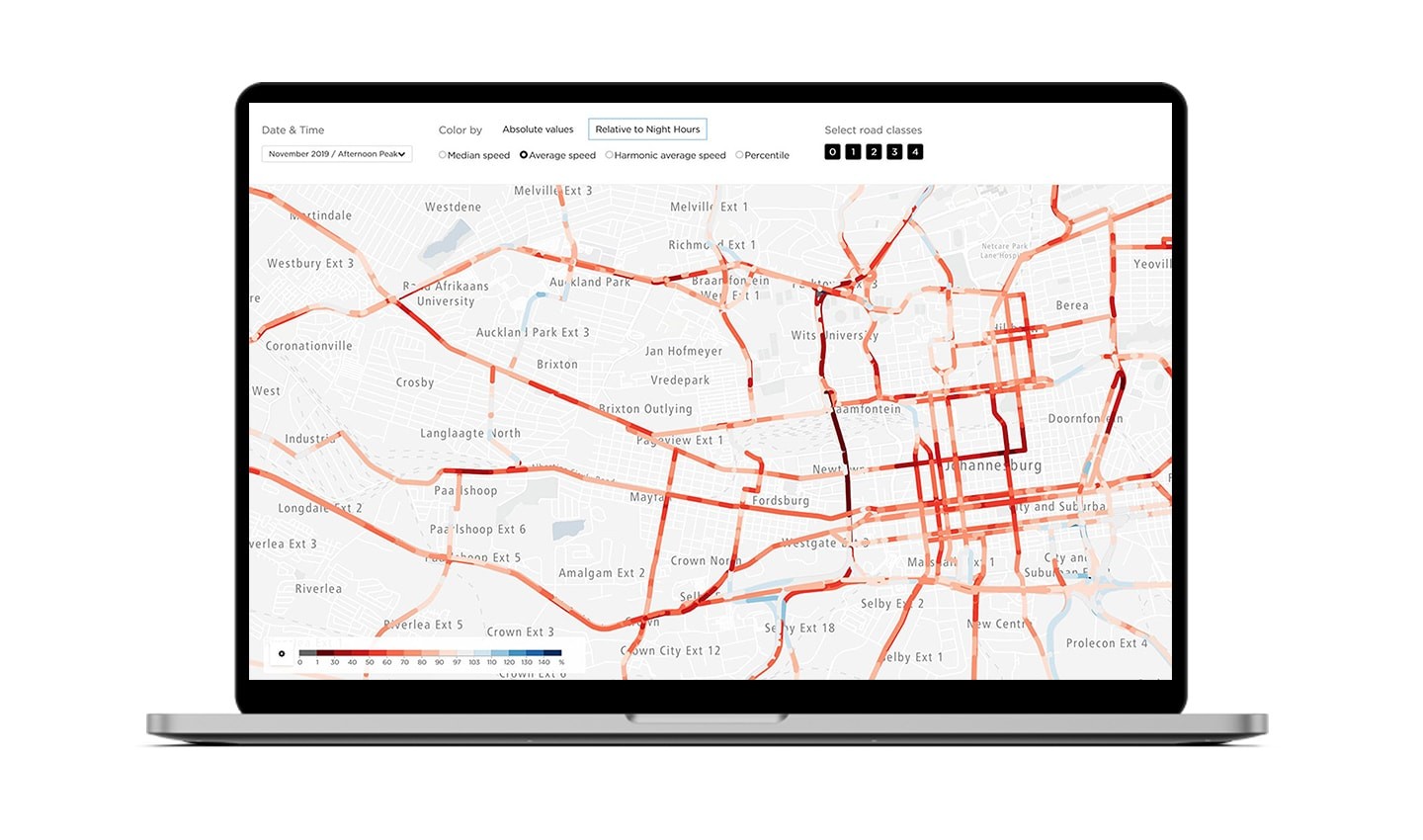
The image above shows travel time percentiles between Brussels and Antwerp during an evening rush hour in November 2015. Public authorities responsible for the Brussels-Antwerp network can use this information for traffic management plans for this specific time slot. Local authorities can de-congest the route by cooperating with traffic information service providers who can reach drivers immediately and directly. They can monitor month-on-month stability to assess the impact of any changes.
Alternative routes service
Road operators face limitations when managing their road network. Control is limited to their specific network and does not necessarily span to networks adjacent to it.
In the case of an emergency, the road operator may need to advise drivers to take a route that they have no information about. Traffic data is available for the road network that the road operator is responsible for but limited or no traffic information is usually available for other networks. As a result, road operators are not able to advise the drivers on alternative routes.
FCD provides the solution to this challenge. As real-time traffic data generated by FCD is road operator dependent, there is instantly data available for all road categories, both secondary and provincial. By integrating FCD data in the traffic management center, the right information is available to make balanced decisions on how to better distribute traffic. As TomTom constantly updates FCD data, it can be utilized throughout the process of rerouting.
Recommended route planning: the most probable path
TomTom designs services so the traffic information that reaches the vehicle is consistent with that on the electronic traffic signs (VMS) on the road network.
For example, when there is a football game in the area of a vehicle’s destination, the navigation system is aware of the event and any measures local traffic management centers are implementing to de-congest the area. This is a win-win for all traffic partners.
The in-vehicle navigation system combines safety with the efficiency of real-time traffic information. There is a convergence between the actions of the individual driver’s objectives (for fast and efficient travel) and those of the public authorities (for adherence to set collective or societal objectives such as CO2 emissions), prioritization of one road user group over the other (pedestrians over cars depending on policy) or other.
TomTom traffic management products
Drivers, companies and governmental authorities all trust TomTom FDC data to provide the most accurate and real-time traffic information on the market. The suite of traffic products is available to suit the specific needs of road authorities, event managers and emergency service professionals to monitor traffic regardless of location.
All products have extensive coverage and utilize vast amounts of driving data to provide personalized insights into traffic management and make the improvements most valuable to road users.
Let’s have a look at what they are.
Traffic Stats
TomTom has been collecting anonymous consumer-driven data since 2008 in over 70 countries worldwide. With data sets containing trillions of traffic measurements, TomTom has built a historical traffic database that is completely unique and unmatched in the industry.
The service provides crucial information for road network performance monitoring and changes in road infrastructure. Users can create a customized query for a specific area or route between specific days. Once the report is made available to view and download, the user gains insight into the traffic situation including identifying problematic congestion spots, average speeds and measuring the impact of a change to a road network between different dates.
Want to learn more about Traffic Stats?
Origin Destination Analysis
As big data is vast and extremely complex, TomTom has developed the O/D Analysis to assist users in making sense of information such as route flows and POI popularity.
The O/D matrix uses TomTom’s big data archive for easy-to-read map visualization that makes it clear to see patterns of everyday movement. Traffic flow maps, for example, visualize preferred routes and trip behavior to determine which regions are best for targeted advertising or a new retail location. In map flows, TomTom visualizes traffic density using different colors on a map of the area and preferred size.
Want to learn more about Origin Destination Analysis?
Route Monitoring
Road authorities, emergency services and event managers need to monitor traffic on key routes to make changes and inform drivers accordingly. In the event of an accident, the appropriate traffic manager must be up to date to take proactive measures to avoid unnecessary congestion.
TomTom Route Monitoring uses real-time traffic information from merging multiple data sources to reveal detailed information on routes defined by the user. For example, authorities can view real-time details about a route that include travel time, delay information and confidence level to easily identify the most congested segments through easy-to-read speed charts.
Want to learn more about Route Monitoring?
Real-Time Traffic
TomTom Real-Time Traffic comprises Traffic Incidents and Traffic Flow. Both services provide highly accurate real-time speed information, live traffic updates and information on travel times on individual road stretches.
Traffic Incidents is a traffic service that is mainly used by navigation products such as satellite navigation devices. Using Traffic Incidents, delays and journalistic information are delivered on all affected roads in the area requested by the customer.
The Traffic Flow service is mainly used by public authorities for traffic monitoring purposes. It helps traffic authorities assess the entire road network since the real-time speeds and travel times delivered by the service cover all road segments.
Both traffic solutions are available immediately and do not require traffic authorities to implement changes on the road network map. As a result, there is no extra time required for developing or installing these solutions.
Want to learn more about Real-Time Traffic?
Get in touch for a personalized solution
Do you want to use TomTom’s award-winning Traffic and Live Services for your traffic management plan?
People also read
)
How TomTom and its partners help road authorities solve traffic challenges
)
How traffic impacts navigation: 4 insights on real-time and predictive flow
)
THTC and TomTom transform traffic management in the Middle East
* Required field. By submitting your contact details to TomTom, you agree that we can contact you about marketing offers, newsletters, or to invite you to webinars and events. We could further personalize the content that you receive via cookies. You can unsubscribe at any time by the link included in our emails. Review our privacy policy.