)
In early November, 2022, TomTom lifted the lid on its game-changing approach to build a new digital map and geolocation data ecosystem, called TomTom Orbis Maps. Data will be key to its success, and while the company already has more than 30 years’ worth of global location data, it’s not resting on its laurels. The Dutch mapmaker is instead taking data sourcing to new heights with what it calls “super sources.” But what are they?
“Data,” Michael Harrell, VP of Software Engineering TomTom Maps, says. “It’s all about the data.”
Whether you’re making a simple map to show where your restaurant is or a high-definition ADAS map for an automated vehicle, you need data. Naturally, the more complex the use case, the more detail and accuracy you’ll need. Equally, the more data you have access to, the more opportunity you have to innovate.
“Jonathan Houston, General Manager Commercial, MapIT
Today, digital maps and location data are used in more business models, applications and in more innovative ways than ever: from geotagging social media posts, to routing food delivery drivers, to informing insurance calculations, to ensuring your bank cards aren’t being misused, to suggesting what the default language on your devices should be.
This vast variety of use cases is placing “insatiable demand” on the kind of technology TomTom develops, Harold Goddijn, TomTom CEO, said at the company’s recent investor event.
For a world reliant on location data, developers and engineers need the best, most detailed digital map possible. The “freshest, most flexible and smartest map on the planet,” as TomTom puts it.
But to begin building that, the company requires data, lots of data. The good part is that there is no shortage of data out in the world. “Location data is everywhere, and it can never be decoupled from our lives,” says Andy Marchant, TomTom Product Marketing Director.
Harrell is much more direct, “It’s a tsunami of data,” he says.
The difficult part is bringing it all together and making sense of it. This is the fundamental challenge TomTom faces every day. As Tara Goddard, Assistant Professor at Texas A&M University, puts it, “How do you find the signal in the noise?”
TomTom Orbis Maps and ecosystem
TomTom’s new Orbis Maps is designed to do just that. It will absorb more data, from more sources, at a greater rate and with greater accuracy than what’s currently available on the market. All with the goal of building a more flexible, interoperable and futureproof map.
“Harold Goddijn, TomTom CEO
“It’s good to have a lot of sources. To make a fresh, detailed map you need a variety of information feeding it into the system,” Laurens Feenstra, VP of Product Management TomTom Maps explains.
For this, TomTom is taking conventional data sourcing a step further through what it calls super sources. Harrell explains that super sources are location data sources that offer a high level of accuracy in a cost-effective manner compared to traditional data gathering methods, like using mobile mapping (MoMa) cars.
In the early days of digital mapping, mapmakers had to drive MoMa cars on every single road to collect the data to build maps. Even though these were time-consuming, expensive and slow to operate, they were the only way to get the quality of data needed to make a map.
Super sources, though, take data sourcing to another level. Rather than having to undertake the expensive task of going out into the world to collect data, with super sources, the data flows directly to TomTom.
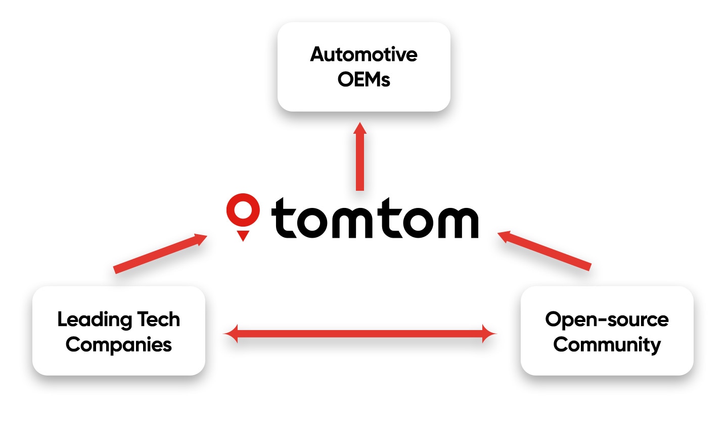
Super sources come in a variety of forms, including observations from automotive OEMS, vehicles, connected sensors, partners and open-source projects, like OpenStreetMap (OSM) and the Overture Maps Foundation. But the goal is always the same: to bring more data together, to create a more detailed and accurate map.
 Data for TomTom's new map flows from various resources. Maintaing relationships with carmakers, tech companies and open-source communities uniquely positions TomTom to assimilate all this data and make a map that can't be rivaled.
With better maps, location-tech companies can increase their efficiency. They can save time, money and resources, all of which contribute to improving the experience for their users.
One of the most appealing data sources TomTom is using to make its new map are sensor derived observations or SDOs for short.
Sensor-derived observations: A mountain of useful data
As the name suggests, SDOs are data observations about the world that are gathered by sensors. In this case, TomTom refers to sensors on vehicles, such as cars and trucks.
Kris Kobylinski, Director Product Management, tells me that, at the time of writing, TomTom collects more than 2 billion observations from vehicle sensors each year, and we’re only just scratching the surface of what’s possible with them.
The average car on U.S. roads is more than 12 years old, according to figures cited by Kelley’s Blue Book. As a result, the majority of cars on the road today are equipped with only basic sensor arrays (or none at all). However, more than 90% of new cars sold come with advanced sensors, including some form of location-relaying device. Within the next decade or so, we can expect nearly every car on the road to feature a more advanced sensor array — that 2 billion figure is going to get a lot bigger.
 Vehicle sensors allow cars to "see" the world around it. The more advanced the sensors, the more detailed the observations it can make.
As more vehicles come equipped with sensors and data-capture systems, the number of possible sensor observations gathered each year is going to erupt and bring with it a waterfall of potential opportunities for mapmakers. Where SDOs now provide a steady trickle of input, they will go on to supply a torrent of mapmaking data. With its new Orbis Maps, TomTom is ready to make the use of this data like no other.
The first type of sensor-derived observations
Essentially, SDOs gather three different characteristics about our roads, Kobylinski says. They capture vehicle trajectory, basic lane geometry and road signs with a value, these could be speed limits, stop signs or weight restrictions.
TomTom has been using vehicle trajectory (aka, GPS trace data and floating car data) to inform changes to its map for a couple of decades now, since the days of the personal navigation device (PND), in fact. This trace data — which shows the location of a vehicle in time — can, in crude terms, be considered the first type of SDO.
GPS trace lines are a simple data point but offer powerful potential. So much so, that with them, according to Steve Coast, Founder of OSM, “You could redraw a map of much of the world every day.” Or even every hour in some busy places.
Trace data from highly accurate GPS systems, coupled with something called dead reckoning (read more about that here), make it easy to calculate where roads are and what the direction of traffic is, spot patterns of congestion, understand speed profiles, and monitor for infrastructure changes and road closures. For a company like TomTom, remapping an entire road network is an elementary task.
Today, there are many more sensors on vehicles, such as cameras, rain sensors, light sensors and forms of radar. With a little interpretation, data from these sensors can be ingested, turned into useful information and applied to the map.
A common use of SDOs today is street sign recognition, Kobylinski explains. Sign recognition cameras are capturing millions of street signs every day, all over the world. It’s one of the technologies that helps make things like Intelligent Speed Assistants possible. Using this kind of sensor data, TomTom can identify speed limit signs and keep its speed limit data up to date in real time.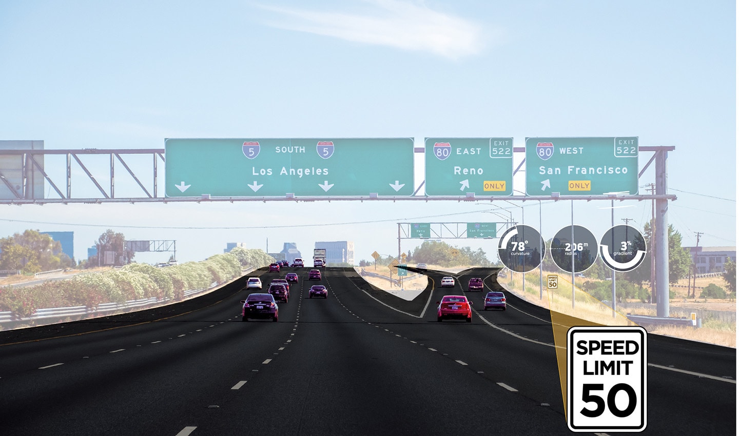 Street sign recognition cameras can spot speed limit signs by the roadside and alert the driver. They can also be used to update TomTom's map of speed profiles and speed limit data.
While each vehicle only captures one instance of a sign, by combining every observation, the mapmaker can know, with a high level of certainty, what the sign is. Comparing this data against TomTom’s 30 years of historical data and MoMa vehicle data, the company can verify if the sign is new, if it’s changed or even if it dissapears, coupled with machine learning and AI and these process can be largely automated to work incredibly fast.
The future of SDOs
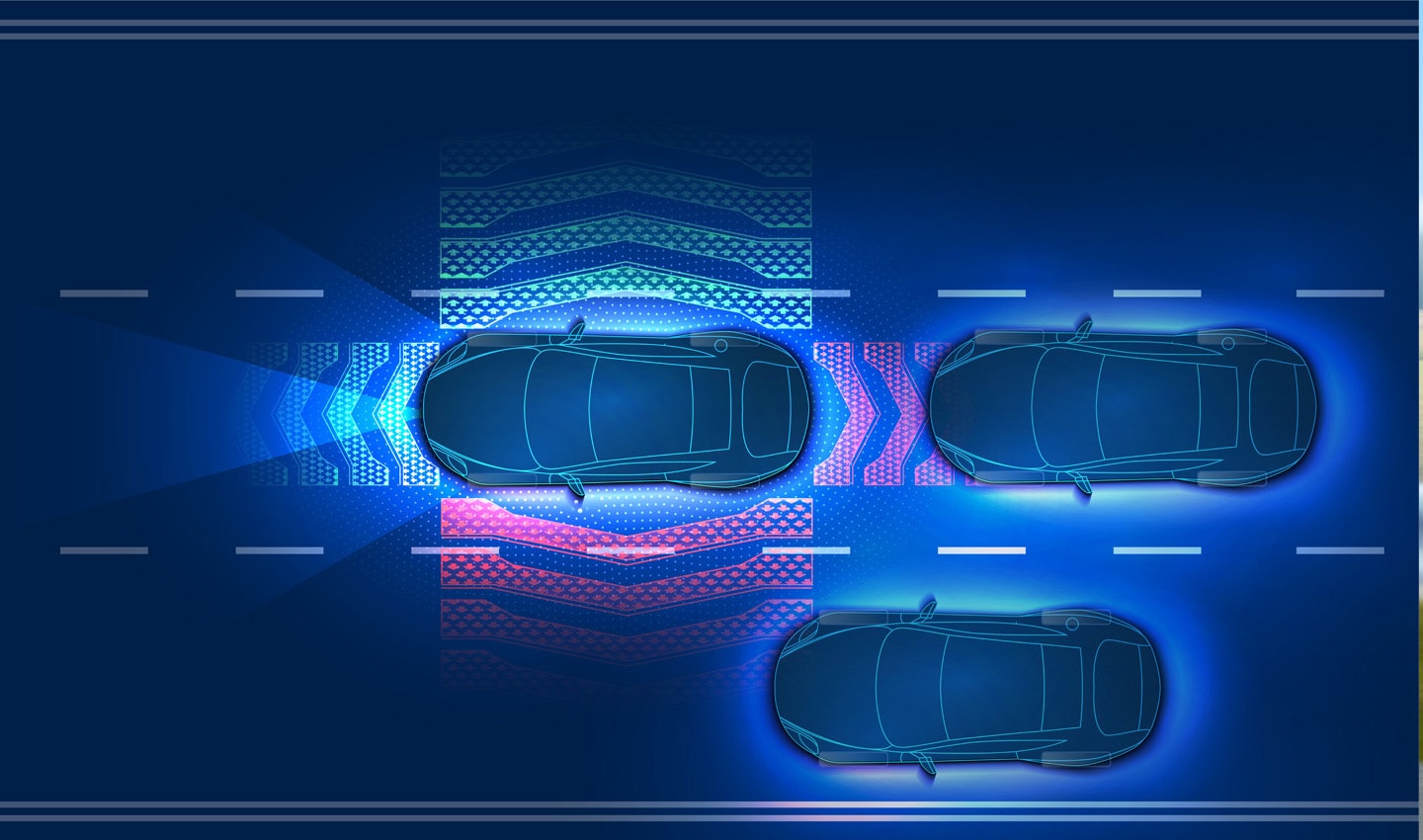
With more complex sensor arrays, in future, every vehicle will be a sort of MoMa car, Harrell says. Cars will be filled with all kinds of sensors and computers and this could have a powerful and broad-reaching ability to inform updates to TomTom’s map, he adds. It will allow mapmakers to go beyond lane geometry, vehicle trajectory and sign recognition.
Think about a vehicle with advanced sensors such as radar, high-resolution stereo cameras and even LiDAR (light detection and ranging, a form of range detection system that uses lasers). The observational potential of these sensors is massive compared to a single street sign recognition camera. These sensors can more accurately map the widths of lanes on a highway, they could identify road markings and the types of vehicles on the road. They could even map objects by the side of the road, such as fire hydrants, benches, building entry points and dropped curbs used for disabled access.

We’ve come a long way from the lone MoMa car slowly scouring the world for data. In future, every car in the world will collect data around the clock and beam it back to TomTom to sift through, so it can update its map constantly. It’s one of the most powerful tools the company has in its mission to make the world’s freshest and richest map and it’s on a trajectory to only get better.
Indeed, it’s certainly a key differentiator against some of the world’s other global mapmakers who don’t have access to the same combination of SDO data, MoMa data and historical insight that TomTom does.
Community and partners: Collaborative mapmaking is the future
While data is undeniably important to TomTom’s maps, so is collaboration.
Traditionally, when TomTom talks about its community and partners, it’s referring to people, individuals or organizations that suggest map edits, make changes to the map directly or make observations and provide data to inform map updates. These range from drivers highlighting when something’s not right on the road through their PND or navigation app, to partners, like ride-hailing and logistics companies, tracking issues with the map and presenting those to TomTom at regular intervals.
TomTom has collaborated with its partners in this way for most of its history [Check out these stories to see for yourself]. But now, with its new Orbis Maps, it will be even easier for partners to contribute to, and benefit from, the company’s pool of global geospatial data. Sharing data among partners is a core part of the new platform’s architecture.
Rather than just pointing out where the map needs an edit or making that edit directly, data will flow more freely between TomTom and its partners to suggest map changes with less human intervention. The data they supply will remain largely the same — this will include road network information, POI data, addresses, street names, location context and so on.
Partners are valuable sources as the data they provide often comes directly from ground truth observations, such as inputs from rideshare and delivery drivers — it’s typically very accurate and relevant to their specific use case, and thus can make a big impact.
 Data for TomTom's new map flows from various resources. Maintaing relationships with carmakers, tech companies and open-source communities uniquely positions TomTom to assimilate all this data.
In some cases, TomTom’s partners prefer to edit the map directly with their own in-house expertise as it allows them to prioritize changes they want to see reflected in the map. TomTom will continue to provide this option to them.
In its current map, TomTom uses partner leads, but with its new Orbis Maps, the bandwidth to accept changes, perform quality checks on them, validate them and push them to the map will increase.
Of course, business critical data will be ringfenced and kept exclusive for each business in their own layer — unless it must satisfy open-source licenses, in which case edits will flow back to OpenStreetMap, for example. Everything else will contribute to making a unified, powerful and robust record of ground truth that will be shared throughout TomTom’s partners, allowing them all to benefit from the data pool’s collective mapping efforts.
When this happens, the quality of the map accelerates. It's not limited by the pace of any one company. And it creates a foundation for innovation as everyone in the industry is referring to the same record of ground truth.
TomTom’s CEO Harold Goddijn stresses the importance of creating a foundation for collaboration with its new map. “TomTom Orbis Maps supports our strategy to foster an ecosystem where the world comes together to create the freshest map on the planet,” he said in the announcement.
TomTom is already talking to a handful of new partners from the tech industry, as well as discussing broader collaborations with a few longstanding partners. While they can’t be named yet, we do know one thing: the broader and more diverse those partners become, the stronger and smarter the map grows.
OpenStreetMap: Intricately detailed maps
TomTom also aspires to extend its definition of community beyond commercial partners, to grow its position as an active member of the OSM community — both in terms of using data from OSM to enhance the new TomTom map in line with its Open Database License (OBdL) and through sharing additional map data and other mapping resources back to OSM editors.
Like many companies that work with OSM data, TomTom has a dedicated OpenStreetMap outreach team to deal with this. It has a dual mission: “Make sure that TomTom’s use and improvement of OSM data is done according to the community’s guidelines and uncover opportunities for TomTom to support the OSM community’s many mapping initiatives,” Salim Baidoun, Community Manager, explains.
Over the past decade, OpenStreetMap has exploded to become one of the best-known and most detailed maps of the planet. Over its 18-year history, more than 9 million people have signed-up to edit the OSM map. At the time of writing, the platform has around 50,000 regular active users per month. Based around the globe, they make around 4 million map changes each day.
“The community is everything in OpenStreetMap, because they’re the ones that create the data,” Steve Coast, Founder of OSM, says.
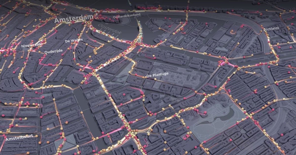
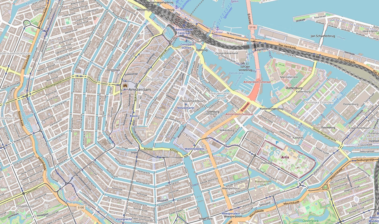 A screenshot of Amsterdam in OpenStreetMap. Credit: OpenStreetMap.
 The level of detail can be astounding. OSM’ers map individual trees, down to their species, trash bins, the color of buildings, types of barriers, fire assembly points and beyond. It’s mind bending. If you want to see all the kinds of feature tags OSM supports, check this out. As a data source, in terms of detail, OSM is one of the best in the world.
“That’s what makes it so challenging to work with. It’s hard to assimilate all that data, it’s just so much detail,” Baidoun explains.
Despite the immense breadth of detail, Harrell says OSM isn’t always appropriate for enterprise use. It’s designed for individual use, it’s not in a standardized format and feature and edit prioritization is left to the community. What’s more, as an entity it’s not structured for companies to work with, making it time consuming and resource intensive when they do. These are not bad things, but they're not aligned to the needs of most corporations that build with map data and need to scale.
OSM is designed to create a free and open map of the world that anyone can contribute to, “The Wikipedia of maps,” as Steve Coast says. It’s not a commercial mapping solution.
“OSM was built for people who walk, ride bikes and hike, as well as drive. By contrast, mapmaking companies must consider mobility, navigation, ADAS and other routing concerns,” Harrell explains. “Combining OSM data with a commercial map takes a lot of time and people and it’s tricky too. But the result will be powerful.”
That’s where TomTom’s new Orbis Maps comes in.
“Frederic Julien, Director Product Management, OSM at TomTom
Before his time at TomTom, Frederic worked in Telenav, TeleAtlas and has been an active OSM contributor for a number of years.
TomTom will be the first global location data provider to directly integrate OpenStreetMap data, Julien tells me.
As part of its new Orbis Maps, TomTom plans to take key data from OSM, validate it and standardize it for commercial enterprise use. Validation includes checking the data for bad edits or vandalization and ensuring everything is as it should be before integrating it with the TomTom base map. If it something isn't quite right, data is quarantined, cross-referenced against TomTom's other sources and corrected accordingly. Standardization is the process of ensuring all the data is in a useful and consistent format.
Like any company that uses OSM, TomTom will ‘share-back’ any improvements it makes to the OSM data as per its community guidelines.
At its Capital Markets Day, the company explained that there will be an uplift to both maps in terms of data. “Those using OpenStreetMap can get the full coverage of TomTom’s road network,” Michael Harrell, VP Engineering TomTom Orbis Maps, said.
It should be noted that OSM data is supplementing what TomTom is building, not replacing it. Its data will allow the company to potentially address use cases beyond navigation, routing and more automotive focused applications.
Speaking to the many TomTom teams responsible for sourcing OSM data, complying with its guidelines and attribution requirements, and engaging with the OSM community, it’s clear they’re taking their involvement with the project seriously. And with good reason too — TomTom’s commercial platform requires quality OSM data. By investing in the OSM community, TomTom’s map improves but so does the OSM platform. It becomes a better, more accurate version of itself. It’s a symbiotic relationship of sorts, one that should benefit TomTom and OSM alike.
[There's a lot to unpack when it comes to TomTom and OSM's relationship. We'll be writing more about that in the near future so be sure to check back.]More data means more value
It’s important to note that many of the sources TomTom is using to power its new map have existed for a while. In some cases, especially with SDO and partners, the company has long used data they gather to inform changes to its geospatial database. It’s also worked with OSM for a while too.
However, there has never been an open, transparent and collaborative platform — a commercial one — through which to assimilate the data from all these places, in one place, in a standardized, quality-checked form and turn it into something valuable and useful that businesses, developers and engineers can benefit from quickly and efficiently.
The days of static geospatial databases are over. To keep pace with the world, mapmakers need to be agile and tooled up to make updates as quickly and accurately as possible. The best way to do that is by using a carefully curated set of high-value sources.
Combining all of these sources will give TomTom the best chance of making the smartest, most accurate map on the planet. A map that can power ride-hailing apps, food delivery, fleet and logistics, insurance calculations and specialist commercial routing algorithms. There's no one else in the market that's taking such a comprehensive approach to building its map.
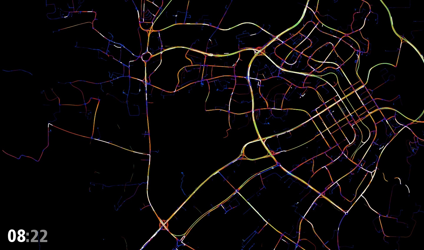
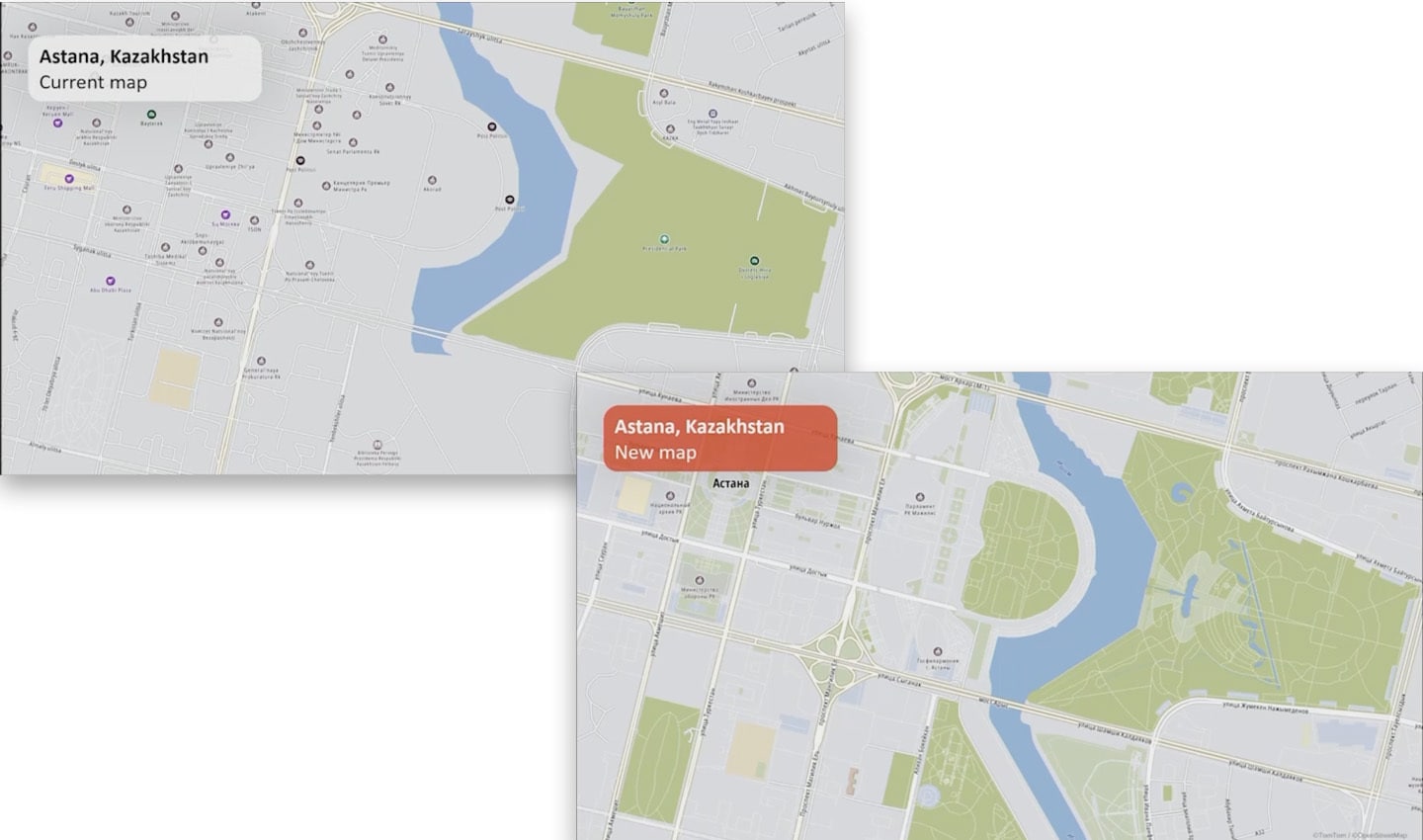 Compare TomTom's current map with its new map. Bear in mind the new map isn't quite finished yet, and it's already showing much more detail. Look at the green space, the intricate road detailing and infrastructure.
TomTom is definitely on to something.
Thanks to the proliferation of and demand for location data, the success of peer-produced geospatial projects, like OpenStreetMap and the willingness of the global mapmaking community to collaborate, TomTom’s new map isn’t going to be bound by the pace of any one company’s efforts.
“It moves as fast as the combined effort of many different companies across the world,” Harrell says. “[The map] even accelerates in what its capabilities are because everybody’s adding their own little pieces of innovation on top of it.”
When companies can worry less about making their own map and turning their location data into something useful, they’re given the space, time, funds and resources to innovate. They have more opportunity to focus on what matters to them, what makes them unique and competitive in the market.
“This open solution should create a significant acceleration in innovation,” Harrell adds.
It’s a big bet. One that no one in the industry has ever made. But it’s one that must be made if TomTom is going to make the world’s freshest and most flexible map. Could it be what’s needed to usher in a new wave of location-based tech? We’ll have to wait and see.
People also read
)
The world needs a better map: TomTom is making it with its new Orbis Maps and ecosystem
)
The Boise boom: How mapmakers keep on top of boomtowns
)
More than 20 years of mobile mapping, here’s how it began
)
How routing algorithms prioritize safety over speed in rural Finland
* Required field. By submitting your contact details to TomTom, you agree that we can contact you about marketing offers, newsletters, or to invite you to webinars and events. We could further personalize the content that you receive via cookies. You can unsubscribe at any time by the link included in our emails. Review our privacy policy. You can also browse our newsletter archive here.