)
It’s been about eight months since TomTom announced its ambitious goal of building the world’s smartest and most useful maps. Progress is being made, so it’s high time we got an update on how it’s all going. We spoke to Willem Strijbosch, VP of Product for Maps, to find out more.
When TomTom announced its new Orbis Maps last year, Michael Harrell, SVP Engineering at TomTom Maps, told us how the company is reimagining mapmaking to be more collaborative and more advanced, using masses of data, machine learning and AI.
He explained how the new TomTom Orbis Maps and maps will galvanize TomTom’s success with current use cases while helping serve the booming and demanding industry of new location-based applications — ones that are poorly served by today’s digital mapping solutions.
For the full recap on what TomTom’s new Orbis Maps is all about and why it could be so important, check out this article. For the latest on TomTom’s new Orbis Maps, keep reading.
The progress
TomTom’s not just making a new map, it’s redesigning and rebuilding the whole structure around it.
How it sources and shares map data, how it processes data and turns it into geospatial insights, how the platform can be used by developers to build new location-based tech and how customers can add their own data and style their maps are all being rethought.
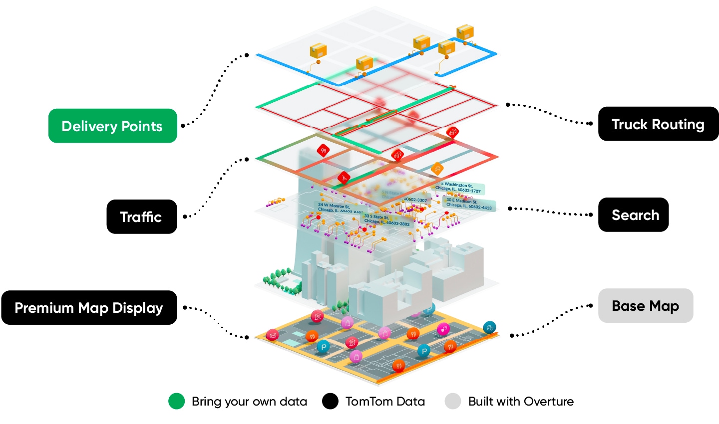 TomTom’s new Orbis Maps builds map and location tech from many layers. These include a base map, private data, visualization, routing, traffic and POIs. (Legend: Gray data layer is built with Overture; Black data layers use TomTom data; Green data layers are your own (customer) data.)
When TomTom’s new Orbis Maps is released, it will open the door for more location tech use cases and set a new standard for collaborative mapmaking, blending open data with high-value, proprietary geospatial tech, to map the world in real-time.
While TomTom only announced its Orbis Maps last year, it’s been years in the making.“Progress has been phenomenal,” Strijbosch says. “Moving to a new platform brings big technical risks, as any tech company will attest, and we’ve experienced that firsthand. However, we’re moving fast, and results from feasibility testing are very promising.”With a big vision come big challenges
Indeed, developing the platform hasn’t been easy. Strijbosch explains the developers working on TomTom’s ambitious real-time map have had to overcome many hurdles. Doing so is all part of the journey, but it’s also what makes building a new and game-changing technology so exciting.
“It’s special to be in a position where you’re reimagining how maps are made,” he says. “Every step we take, we see that we’re getting closer to our vision.”Even though the vision is big and bold, it’s crystal clear. That clarity is proving to be crucial in rallying and energizing the organization and employees working on it. But just because it’s clear, doesn’t mean it’s easy.Putting it bluntly, TomTom is moving from map to maps. Or in other words, it’s evolving from being designed for a few use cases to a whole world of potential applications. Strijbosch says this is, “An enormous challenge that affects all parts of mapmaking.”
“Typically, mapmakers provide access to a single proprietary map [hence the singular above] that needs to serve and work for all use cases. It’s like walking into a coffee shop and only being served espresso. It’ll work, but for a small number of people for some of the time. That’s not what customers want,” he adds. TomTom’s new Orbis Maps offers more choice than that.
Indeed, during its Capital Markets Day, TomTom’s Chief Revenue Officer, Mike Schoofs said the choice and opportunity TomTom’s new map offers will greatly increase the company’s addressable market. “We [TomTom] will gain market share and unlock new [business] segments.”
“Today we play in half the market with existing segments, if you take all new segments, we get to play in more than 80% of the market,” he said.
For Strijbosch, the biggest challenge TomTom has had to overcome is designing and building the system so that it works across all these different uses cases, for many types of customers that build many types of technology.“One customer will want routing for two-wheelers, another will want it for passenger cars. The turns these two vehicles can make are different. One customer will want to store how much electricity their EVs are using on stretches of road, by model and year — to improve range calculations and efficiency. Another customer might want a map to embed in their social media app to help users find interesting places.” One map can’t possibly work for all these uses cases.
TomTom’s new maps couldn’t come at a better time either. Over the past few years, we’ve seen an explosion in on-demand services, EVs, public transit options, location-based social media and an increase in two-wheeled transport and commuting. But overcoming this vast array of demands from the map(s), has led TomTom to design its platform from the ground up to fulfill all current customer needs while leaving the door open to satisfy new ones.
The data behind the map
Last year, we spoke to a number of TomTom’ers about what’s going to power its new Orbis Maps. The short answer: super sources. The long answer: a massive tsunami-like wave of data from vehicles, open data sources, on-ground observations, proprietary and private data and more.
The flexibility to benefit from all these sources, and for customers to bring their own data and keep it safe and secure, is a core part of the platform. And it’s another key part of making a platform that works for all customers, not just a few. “All customers have broad and varying demands of the maps they use,” Strijbosch explains.
“One customer will want to add their own feature data to the map that they cannot share with anyone else. However, another customer might simply want the best, most detailed map they can get. Both extremes can be catered for.”
Think of a logistics firm putting all its warehouses on the map, complete with detailed entry points and loading bay layouts. Only the logistics firm need know this detail. For security reasons it’s best that the information is kept private too.
The most useful map then is one that can be tailored for each customer, their needs and their own data.
Let’s look at what’s new on the map
Maps are — among many things — data visualizations, which makes it easy to compare them. It’s easy to see from a map’s detail, features and geographical coverage, how useful it will be to you and how it stacks up against another map.
In today’s world, more and more demands are being placed upon maps. On-demand delivery companies expect details about building entry points and footprints, middle-mile logistics firms need exception routing and ride hailing apps need insight in to where they can and cannot pick riders up from. For TomTom, this means that the world’s most useful and smartest map must be the most universally detailed one.
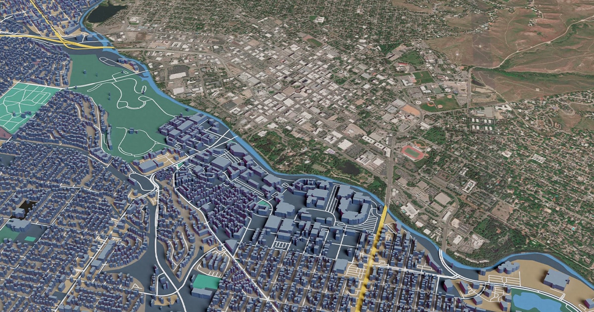
Look at the images below that compare TomTom’s current map (top line) to the map created by the new TomTom Orbis Maps (bottom line), and you’ll see a few things.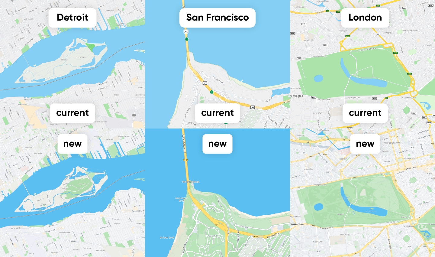 The images above show comparisons between TomTom’s current map and the map generated by the new TomTom Orbis Maps.Across all examples above, you’ll see that road networks are very good. TomTom’s use cases have historically leant towards automotive and other road-based applications and the company has excelled at mapping these features.However, you’ll also see dramatic improvements in detail for parkland, footpaths, geological features, bike lanes, train lines and building locations. The kinds of things that are incredibly relevant to new on-demand delivery models, ride-hailing, two-wheeled transport, insurtech and more.
As Eric Bowman and Harold Goddijn (TomTom’s CTO and CEO, respectively) stated at TomTom’s Capital Markets Day, this increase in detail, coupled with the ability to blend the data each customer requires, is what will help TomTom cement its position in fast-growing markets like ride-hailing, on-demand local delivery, logistics and fleet management.
Consider the example above for San Francisco, USA: the roadways, paths, access roads and the parkland’s geography itself are mapped in much more detail. This kind of map detail will be a huge benefit to fleet and logistics, or at-home delivery companies, who often must navigate the last 100 meters of a delivery, find building entry points and navigate complex areas.
Those that rely on two-wheeled transport, or even pedestrians, stand to benefit too. A map this detailed, across such a broad range of features, packaged in an enterprise-ready format, is surely going to bolster current use cases and open the door to new location-based applications.
What’s next?
Strijbosch, and the wider team at TomTom, are rightly enthusiastic for what’s to come.“We’re at a very exciting moment for TomTom. There’s been overwhelmingly positive feedback and progress has been great so far. We can’t wait and will be thrilled to bring TomTom Orbis Maps to a large audience,” he says.But he’s also quick to stress that this is just the beginning. The TomTom Orbis Maps is a living and breathing technology. As customers start using it and bring their own data, that further helps it grow and improve, with more improvements more uses for it will surely be found. The more we use it, the more its data can be honed, the stronger and more useful it will become.People also read
)
The world needs a better map: TomTom is making it with its new Orbis Maps and ecosystem
)
Super sources will power the 'freshest map on the planet.' But what are they?
)
What shipping containers can teach modern mapmaking
)
TomTom, Amazon Web Services, Meta and Microsoft join forces and launch open map data foundation
* Required field. By submitting your contact details to TomTom, you agree that we can contact you about marketing offers, newsletters, or to invite you to webinars and events. We could further personalize the content that you receive via cookies. You can unsubscribe at any time by the link included in our emails. Review our privacy policy. You can also browse our newsletter archive here.