)

Picture this: your city needs to expand its public transport infrastructure, and you’re responsible for figuring out the best spots for new connections. You have lots of data, from existing public transport sites to everyday commuter patterns. To map out your datasets — and convert them into actionable insight — you first need to make them interoperable. Enter TomTom Global Entity Matcher (GEM).
[TomTom GEM can be explored on TomTom's product exploration platform, TomTom Discover. Just click here.]
This is just one of many use cases. Geospatial data is advantageous across all sorts of operations, from revealing the best strategies for scheduling road maintenance to optimizing emergency-service deployment. But to make the most of your private datasets, they need to become interoperable — meaning that they align with a standard reference system for organizing data.
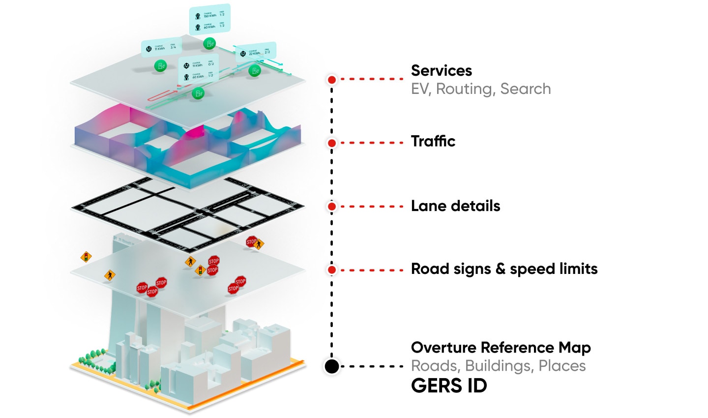 Today’s maps don’t just capture the world’s geographical details — they update to reflect the moment-by-moment changes of reality. This is organized by several layers of information, from foundational layers such as the road network, through to higher layers like live traffic patterns and store opening hours to road signs and speed limits.
Meet your matcher
TomTom GEM is a service that automatically aligns your data with Overture Maps Foundation’s Global Entity Referencing System (GERS). Overture is an open-data platform. It provides the ingredients for a map’s base layer — essentially, the buildings, roads and places upon which other data layers (such live traffic patterns, speed limits and road signs) are stacked. These real-world geospatial entities are linked to stable IDs, which together create a globally standardized, up-to-date reference system.
[Read: How TomTom turns open data into the Overture transportation layer]
Normally, integrating proprietary datasets with open or commercial maps platforms is a painstaking process. But TomTom GEM does this automatically, sparing you the costs, errors and time of manually tackling conflation.
By using advanced algorithms, including deep-learning models, GEM finds the best matches between your geospatial data and the elements on Overture’s map, then scores them based on match confidence. And let's say your data includes roads. TomTom GEM detects where the geometry of your data corresponds with mapped roads and to what extent. Using linear referencing, it treats these roads as single entities no matter how many overlaying attributes vary along its course — making it easier to accurately add or update things like speed limits or restrictions without breaking the road into attribute-specific pieces.
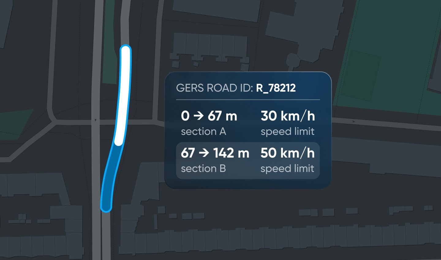 Instead of breaking a road into segments to account for changes in speed limit, TomTom GEM uses linear referencing to treat each road as a single entity, with attributes like speed limits overlaying it.
What’s more, TomTom GEM keeps your map fresh, periodically re-running the matching process to make sure that the real-world updates made to GERS IDs are represented in your map. And should any significant changes alter these IDs, GEM helps connect old IDs to new ones — ensuring clean, connected datasets, long after you’ve onboarded.
[If you want to experience TomTom GEM for yourself, be sure to check it out on TomTom Discover, the company's multimedia product exploration tool. Click here to see TomTom GEM.]
Maximizing your data’s value
But the biggest advantage to using TomTom GEM is that your datasets become interoperable — meaning that they’re compatible with other datasets also aligned with GERS.
The implications of this cannot be overstated: making your datasets interoperable with a globally recognized, stable reference system is far more than a technical upgrade — it fundamentally transforms how your data can be used, shared and integrated. This paves the way for partnerships with other organizations around the world and enables you to participate in a broader ecosystem of map-based solutions. Interoperability means that your data can power new applications, improve existing ones — and support collaborative efforts to solve problems too complex or large for any one organization.
TomTom GEM also makes your datasets compatible with TomTom Orbis Maps, which combines Overture’s open data with a range of even more powerful, useful map data layers, such as points of interest, traffic and routing. Orbis essentially builds on the advantages offered by Overture, its proprietary data and analytics technology delivering even more context, insights, solutions and, ultimately, opportunities for innovation.
People also read
)
How TomTom turns open data into the Overture transportation layer: Road Sectioning
)
Open, flexible, built for business: What makes TomTom Orbis Maps so alluring for location tech
)
TomTom, Amazon Web Services, Meta and Microsoft join forces and launch open map data foundation
)
'Collaboration is the future of mapmaking': TomTom and Overture speak at OSM's State of the Map 2023
* Required field. By submitting your contact details to TomTom, you agree that we can contact you about marketing offers, newsletters, or to invite you to webinars and events. We could further personalize the content that you receive via cookies. You can unsubscribe at any time by the link included in our emails. Review our privacy policy. You can also browse our newsletter archive here.