)

When maps can provide trusted and verified ground truth across entire continents, why wouldn't you use one as part of your automated driving software stack?
There are many ways you can build an automated vehicle. You must devise a way for the car to “see” the world, choosing from a host of sensors: stereo cameras, LiDAR, GPS/GNSS, radar, sonar and speed for example. Then you must blend these together with software, so the vehicle can understand its environment. But these kinds of sensors are not always accurate, and sometimes operating conditions dramatically reduce their effectiveness. Maps on the other hand are never affected by adverse conditions and thanks to being updated in near real time, they can provide a level of ground truth and context that can scale across entire continents. A high quality, lane-level map should be at the top of any automated vehicle maker’s shopping list.It’s not surprising that TomTom takes this stance. But when some influential industry players suggest that maps are an unnecessary extra cost for ADAS technology, the company believes it’s important to reinforce that that’s simply not the case. Maps are essential for the functioning of ADAS, automation and self-driving vehicles, providing a level of locational insight that sensors will never match. They’re essential for AD safety.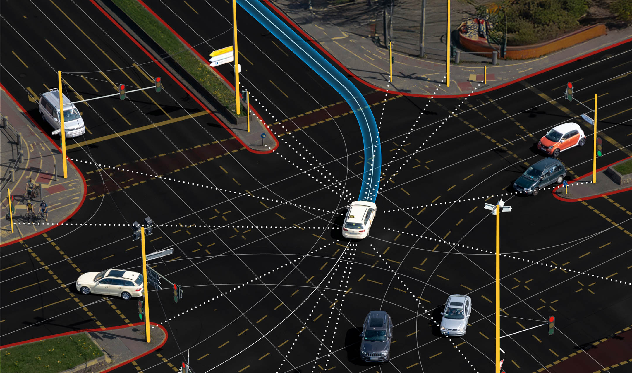 Fusing real-time sensor data with validated maps for ground-truth leads to a powerful understanding of the world.
Back in January, TomTom announced a significant deal with CARIAD, the software arm of VW Group, which will see the carmaker use Orbis Maps in the software stack behind its automated driving tech. The deal is significant for several reasons, but perhaps most of all for those watching the movements of the industry, it shows that maps are, and will continue to be, a vital component of automated and autonomous driving systems. Even if some believe the opposite.
[Read: TomTom Orbis Maps to power CARIAD’s Automated Driving systems]
The “mapless” argument misses what really matters
Can you build an automated vehicle without a map? Of course you can. Whether you should is another question.
Indeed, some noteworthy names in the automotive industry continue to push the idea that sensors alone can deliver safe, scalable automated driving. It’s an appealing narrative with systems promising to be elegant, minimalist and friction free. But it overlooks a simple truth: sensors can only see the world right ahead, as it is right now. They can’t always see through fog or snow, or in direct sunlight. They can’t see around blind bends, through buildings, through the car in front or through the haulage truck hiding your exit sign.
Even the most advanced neural networks cannot infer beyond these limitations when the underlying data is incomplete. But maps provide the solution. Maps don’t just complete that data and step in where sensors fall short, they provide a trustable base-level ground truth that ADAS systems can refer to.
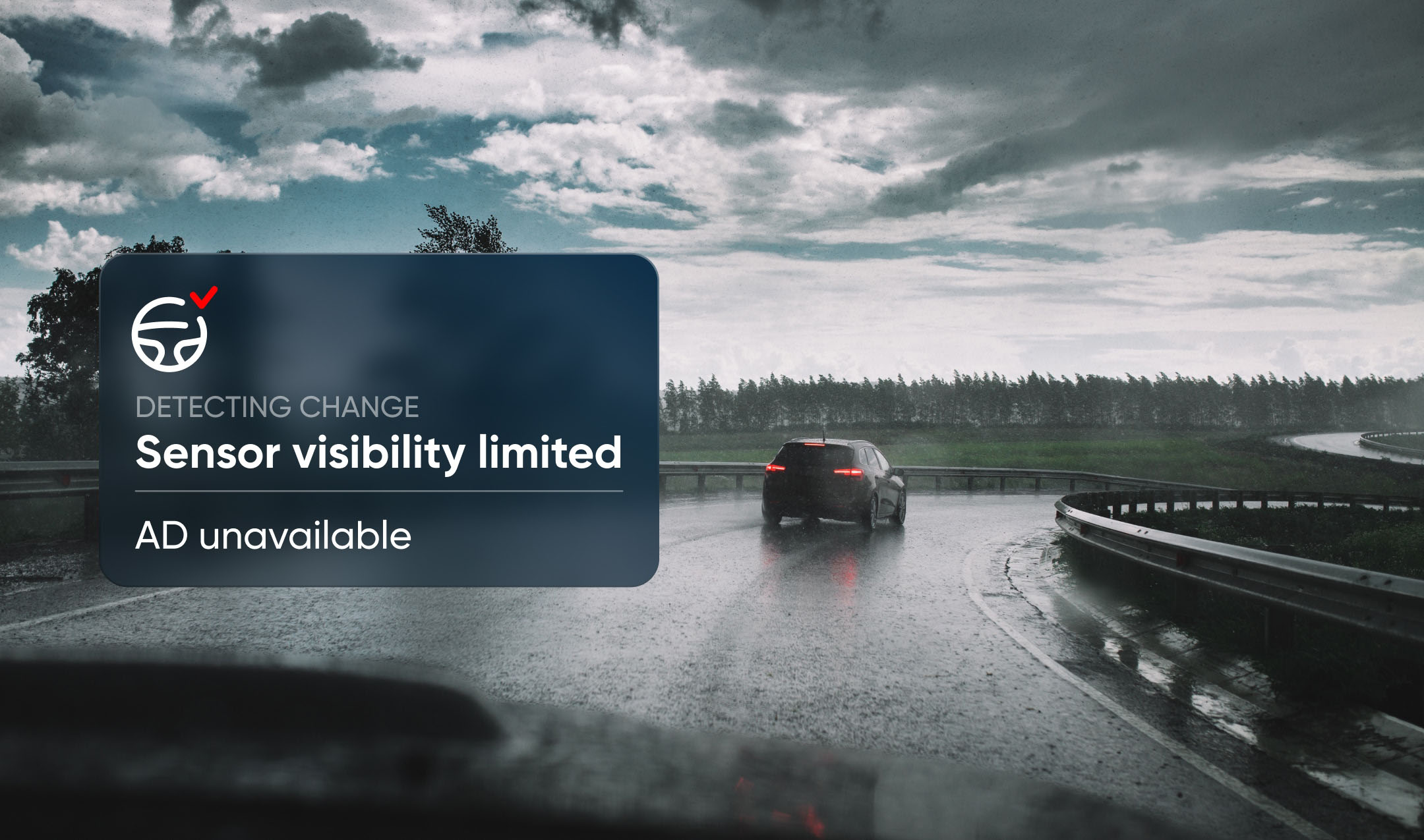 When sensors are obstructed or incapable of working in the prevailing conditions, maps provide valuable safeguards.
Maps can allow a vehicle to anticipate turnings in inclement weather. They can anticipate the geometry of the road around corners and blind bends, and even alert of hazards and traffic. And of course, using a quality map will mean you never miss an exit.
Maps provide the context, continuity and foresight that automated driving technologies need to behave predictably. And when many drivers turn off their ADAS citing that it's jarring, annoying or overly invasive, increasing predictability can only be a good thing.
Maps turn reaction into anticipation
A high‑quality map gives a vehicle the ability to plan ahead — even further than a human could. It knows the shape of the road before it comes into view. It knows that a lane splits, that a tight curve is approaching, that a speed limit changes halfway along a bridge.
While some may suggest that this is “extra complexity” and creates additional development overhead. It’s undeniable clarity. It allows the system to drive less like a robot reacting quickly to instantaneous observations and more like a human who has driven the road many times before.
[Read more: There’s no such thing as mapless automated driving]
The difference here is that while a human might know one city’s worth of roads well enough to predict traffic patterns and plan for danger, the map-powered AD vehicle has the potential to know every road, in every city, in every country, and drive them like a local.
CARIAD’s choice shows where the industry is heading
That’s why CARIAD’s recent decision to adopt TomTom’s Orbis Maps is an important moment for the industry. When the software division of one of the world’s biggest carmakers chooses a lane‑level, continuously updated, AI‑native map as a core element of its automated‑driving stack, it sends a clear message: maps aren’t an option, they’re a foundation of automated driving systems.
CARIAD isn’t alone in this thinking. Across the industry, there’s a growing recognition that combining sensors, AI and lane-level maps creates systems that are not only more capable, but more explainable, more robust and easier to scale across geographies. We’ve seen it with intelligent speed assistance (ISA) tech, where map/sensor fused systems greatly outperform sensor-only versions.
If applied correctly, maps don’t have to compete with sensor perception; they can strengthen it.
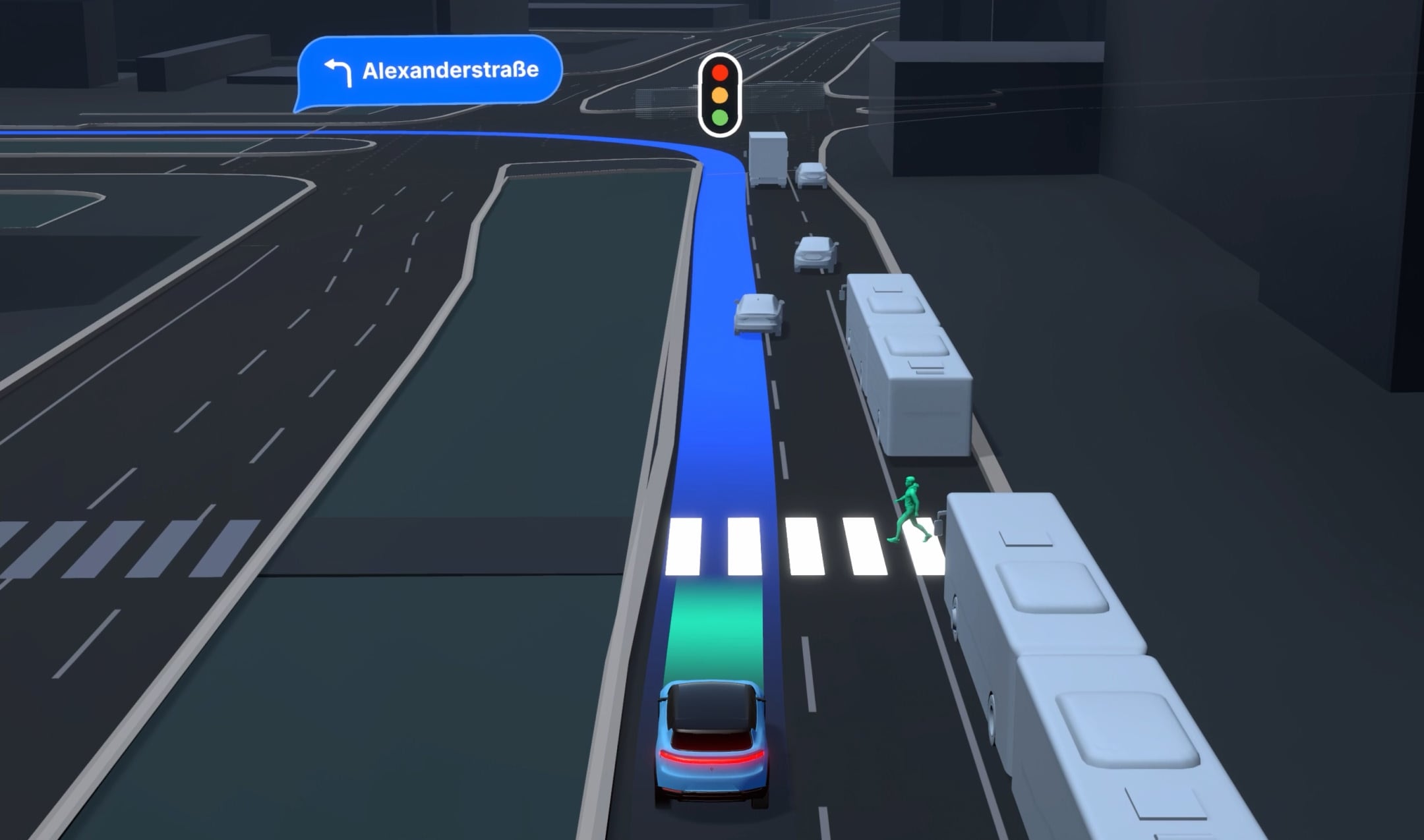 While sensors can see things in front of the vehicle that cannot be mapped, like moving people, the map can provide centimeter accurate road geometry, insight on upcoming traffic signals, turns and hazards.
A hybrid future: Sensors and maps working together
The real path forward for automated driving is hybrid. Sensors provide real‑time perception. AI interprets the scene. And maps supply the grounded, reliable structure that ties it all together and ensures the AI isn’t hallucinating. That’s the approach that delivers safety at scale — and it’s the approach the industry must converge on, for safety, reliability and trust.
As automation advances, the stakes rise. Consumers, regulators and manufacturers expect systems that don’t just work, but work safely, consistently and transparently. And that requires more than raw sensor data. It requires knowledge, the kind of knowledge only maps can provide.
Maps don’t complicate automated driving. They make it trustworthy.
People also read
)
There’s no such thing as mapless automated driving
)
How can a map be ‘built for business’, what does that mean?
)
How risk tolerance shapes ADAS regulation: The U.S. and European approaches
)
How ADAS helps truck drivers stay safe and drive efficiently
* Required field. By submitting your contact details to TomTom, you agree that we can contact you about marketing offers, newsletters, or to invite you to webinars and events. We could further personalize the content that you receive via cookies. You can unsubscribe at any time by the link included in our emails. Review our privacy policy. You can also browse our newsletter archive here.