)

A few years ago, Orbis Maps introduced a new generation of global mapping technology. “The new map in town” promised to not only be richer, fresher, faster and more versatile, but also to keep on evolving – continuously gaining coverage and data to become an even more advantageous solution across industries around the world. You may be wondering: where is Orbis Maps now? Get the full story, check the latest stats and find out why data formats are so important.
A map on a mission
Let’s start at the beginning. In 2022, a story of global collaboration came to life when TomTom announced Orbis Maps. By partnering with the Overture Maps Foundation and the OpenStreetMap community, TomTom created a unique open map that no single mapmaker could achieve alone.
With Orbis Maps, TomTom set forth a new standard in mapmaking to bolster a future of location-based innovation and industry-wide collaboration. This leap into a new generation of mapping technology came right when it was needed, as a rapidly changing world demanded more powerful geospatial data to keep people and goods moving safe and sound.
As TomTom says, Orbis Maps is built for business. Its standard is key to bringing versatility and ease of use across industries, and allows for open sources. TomTom has a strong partnership with OpenStreetMap (OSM) community. By combining the best of both open and proprietary data, Orbis Maps offers exceptional coverage, richness and accuracy, even in remote areas.
The smartest map – that’s always getting smarter
One of the beautiful things about Orbis Maps is that it’s designed to continuously grow and improve, as data is updated and validated from a multitude of sources. An AI-powered system of rigorous checks maintains quality and real-world change mirroring. More, higher quality data means more possibilities for both Orbis and its users.
For example, earlier this year TomTom announced immersive 3D lane geometry for any road, adding a new dimension for automated driver-assistance systems (ADAS) maps. By mapping the world in 3D with unmatched coverage and precision, TomTom empowers automakers to build solutions for higher levels of vehicle autonomy and safety, while also providing urban planners and governments with the insights they need to create more efficient cities.
Orbis is showing its capabilities as an intelligent map that increasingly helps customers and partners across industries, such as mobility on demand and ride hailing, fleet and logistics, and the government and public sector.
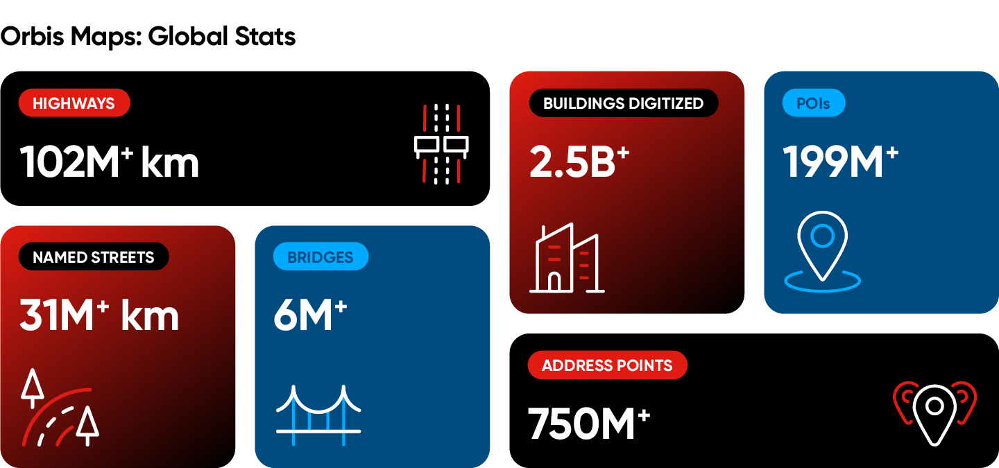
Zooming in: Orbis Maps in numbers
If you’re wondering what a global map like Orbis looks like in numbers, just take a look below. We’ve gathered the latest metrics, showing everything from total kilometers of road network, to how many points of interest (POIs), addresses and more are currently covered by Orbis Maps.
Giving the data value: Integration and delivery formats
If customers and partners can’t integrate the data, it has no value. Lucky for anyone using Orbis Maps, it delivers data in all common formats for easy integration and interoperability. This way users can choose the right format for their specific use cases and performance needs, making it faster and easier to get real-world results from the data.
For example, the Protocolbuffer Binary Format (PBF) is a highly compressed, open standard commonly used in the OSM world. It’s well-suited for applications where data portability, compactness and cross-platform interoperability are more critical.
Esri’s File Geodatabase (FGDB), on the other hand, is a structured collection of files that’s fully compatible with ArcGIS applications and offers efficient data storage and retrieval. It’s more suitable for complex GIS projects that require advanced spatial data management and analytics capabilities, especially within the Esri ecosystem.
While Orbis Maps has provided delivery in PBF and other formats, FGDB is a notable new addition. Why?
Unlocking geospatial use cases with FGDB
By making Orbis Maps available in the Esri FGDB format, TomTom is opening up its map for faster and easier use in the GIS and location analytics market. That includes important, large-scale use cases by the government and public sector – from public safety and homeland security to infrastructure planning, helping create smarter cities and more sustainable mobility.
Without a widely adopted and standardized format like FGDB, processing and analyzing vast amounts of map data can be tiringly complex and time-consuming. Especially when you are combining data from multiple sources, which GIS customers usually are.
Having Orbis fully compatible with Esri ArcGIS applications allows users to instantly load the map data and use it for driving decisions in geospatial analyses. Everything works out of the box. Even engineers and data analysts with limited technical background and expertise can use tools like ArcGIS to load, analyze and combine data to gain insights and make strategic decisions.
Onwards: More data, accessibility and impact
Orbis Maps launched as a unique next-generation mapping solution, being the first of its kind to combine open and proprietary data, and to be built on an open standard. Since, it has proven to deliver standout capabilities while remaining on a trajectory of continued growth and innovation.
TomTom’s MO for Orbis Maps is not only about having the most data, but also making sure that the data is accessible for customers and partners to achieve their goals and make an impact.
What’s next for Orbis Maps? Stay tuned for more on the ever-evolving journey, where real-world data makes a real-world difference.
People also read
)
Watch: TomTom VP of Product on new 3D maps for ADAS and more
)
Mapping road risks: How AI and data are revolutionizing traffic safety
)
Making maps at scale with AI and machine learning
)
Open, flexible, built for business: What makes TomTom Orbis Maps so alluring for location tech
* Required field. By submitting your contact details to TomTom, you agree that we can contact you about marketing offers, newsletters, or to invite you to webinars and events. We could further personalize the content that you receive via cookies. You can unsubscribe at any time by the link included in our emails. Review our privacy policy. You can also browse our newsletter archive here.