)
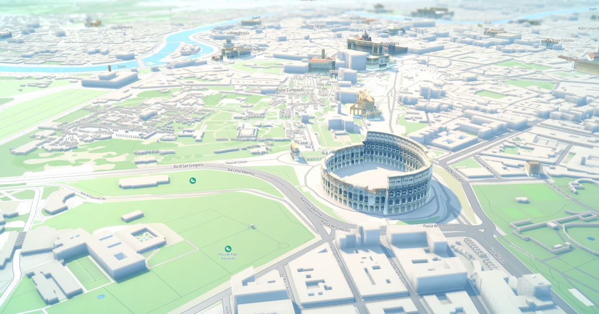
TomTom Orbis Maps is a game-changer, and now it comes in 3D. With greater likeness to the real world Orbis Maps offers enhanced safety and navigation by providing detailed road geometry and lane-level information. But with an ever-changing world, how can we keep up? TomTom builds its maps using machine learning and AI to automate map creation and updates, ensuring high precision and frequent refreshes. Based on multiple, diverse sources of data, they support autonomous driving and beyond, and can be tailored to specific customer needs. We spoke to the experts and took a deep dive into the technology, which is opening new possibilities.
Back in 2021, predictions were bullish that the streets would soon be crowded with fully autonomous vehicles. Fast forward to today, and advances have been slower than some in the industry might have hoped. “We might get there one day but we still have a role to play there now,” said Benoit Joly, Senior Vice President of Automotive Sales at TomTom. “Safety is and remains a key topic.”
As original equipment manufacturers (OEMs) progress more gradually through the stages of automation, highly accurate, reliable and regularly refreshed maps play an important part in helping them achieve safety goals without putting passengers and drivers at risk. These detailed and reliable maps are also bringing the next generation of navigation to drivers. That is where TomTom’s Orbis Maps comes in.
“We have approached Orbis Maps in a radically different way,” Joly said. “Orbis Maps is 3D native, meaning that we are mapping the world in 3D and ensuring that we bring that level of detail to maps as the baseline for Orbis.”
Instead of creating a basic map then adding features as required, for use cases such as autonomous driving, for instance, TomTom’s Orbis Maps starts with the highest quality and most detailed information available. That includes lane-level navigation and fine detail on complex urban locations, such as crossings, bridge heights and traffic lights.
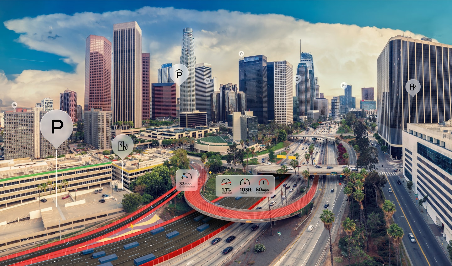
When navigation systems are based on granular information, drivers not only get from A to B more safely, but they can also enjoy a richer and more enhanced navigation experience. The option to choose packages of features and attributes according to specific business needs brings further flexibility to carmakers and OEMs.
How TomTom Orbis ADAS maps are built
One of the biggest challenges for automakers looking to introduce more automated features to cars is that city centers are inherently more chaotic and complicated than highways. What works for the latter might not be enough for the former. The need for a detailed, up-to-date map that can help the vehicle understand what is going on everywhere becomes vital for safety reasons. “The challenge we set ourselves was to make an ADAS map for every road with a production method that is not super expensive and allows use to keep the map fresh,” said Laurens Feenstra, VP of Product at TomTom.
The solution came with advancements in artificial intelligence (AI). Using a combination of foundational models and internally developed AI models, TomTom has developed an algorithm that can be applied to various sources of data to build the ADAS map rapidly. Since most of this process is automated, it can be done much more quickly than traditional methods and can scale across the globe.
Feenstra estimates that 90 to 95% of the changes and updates made to the ADAS map are detected automatically by TomTom’s AI models. This transforms a manual process that would take months into automation that takes minutes. This brings a huge leap in efficiency and reduction in costs too. “Historically, building these things [Orbis 3D and ADAS features] has been very expensive. You have your survey vehicles with expensive sensor suite on top and you drive them everywhere then you have humans look at the images and start building the maps by hand,” Feenstra adds.
Machine learning, human oversight
Another advantage of Orbis Maps is the large variety of sources and inputs that go into it. TomTom uses a combination of satellite imagery, lidar and radar, camera and sensor data, open data and high-definition information collected from its own vehicles. This mixture of data, including fresh data from cars that are driving in real time, creates a rich and fresh picture of what is happening on the roads. “When you start aggregating all that, you get a pretty good picture of what the world is like,” Feenstra said. The challenge is in the aggregation.
With different sources having different strengths, the comprehensive picture they build together can help make driving safer. “There are a lot of cases where the ADAS map is an additional safety belt compared to trying to use just the perception sensors on-the-fly,” Joly added.
However, while automating the processing of this bundle of rich source material can speed things up, humans have not been removed from the process entirely. “Humans are still very important,” Feenstra added. “You need a lot of data to train your AI, and every algorithm can still make errors, so we need humans to spot those errors and fix them.”
A team of data scientists and machine learning engineers are on hand to make sure the algorithm stays on course, in a coming together of human and machine that is designed to get the most accurate, high-quality result in the least amount of time. The beauty of this approach is that the algorithms learn from these corrections, getting faster and more accurate as they progress, and reducing the human overhead.
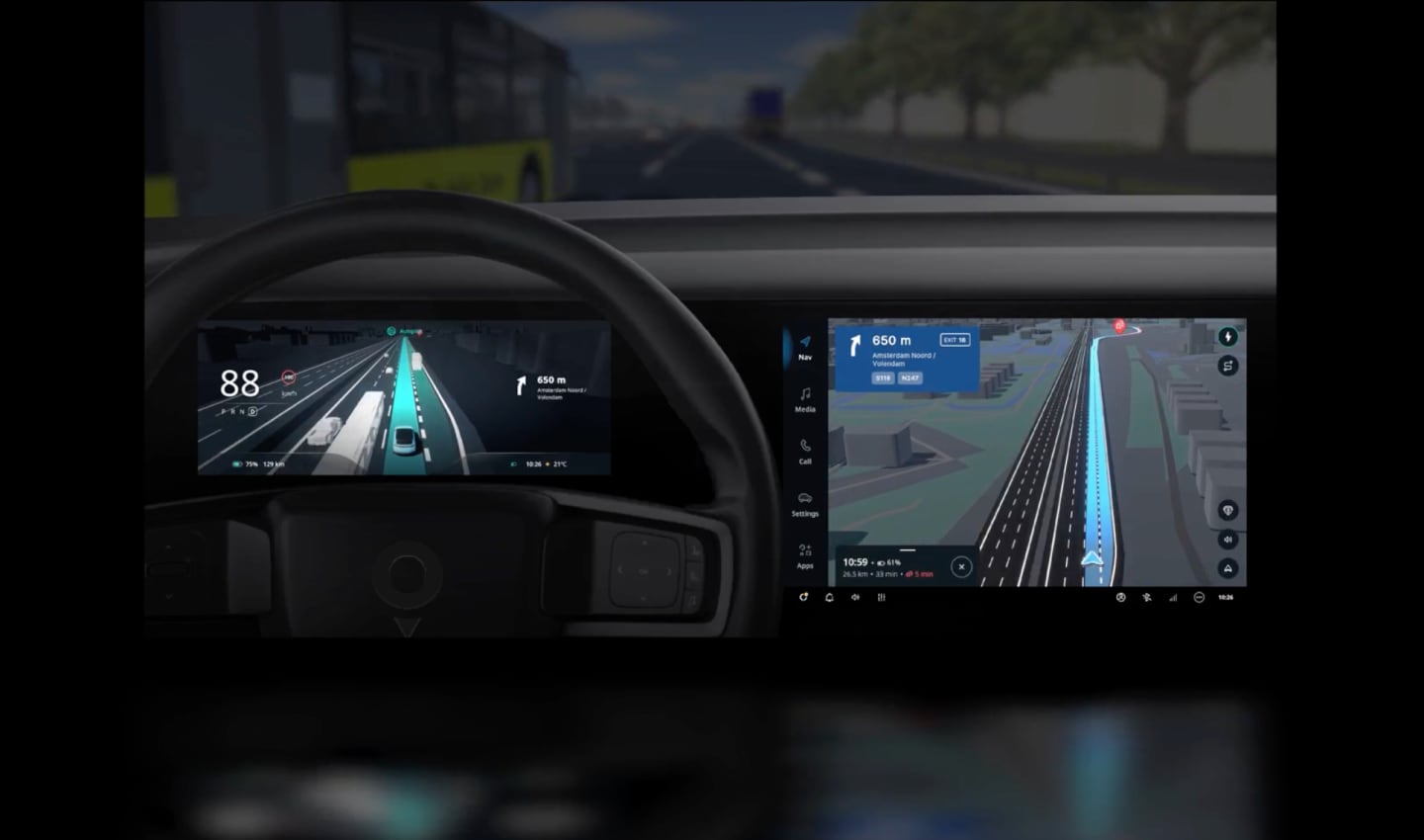
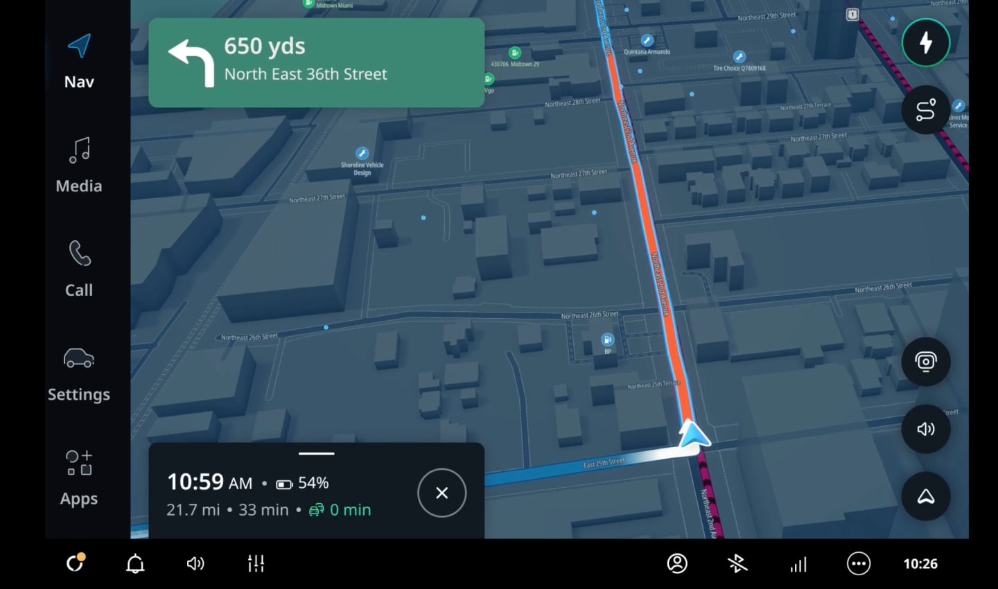
“The other thing is the visual richness this gives us humans who are behind the steering wheel,” he said. Anyone who has driven in an unfamiliar city and found themselves confused by the unrelatable image on their navigation screen, missing a turning as a result, can understand the benefit of this. “The geometry [in the map] gives you a more realistic visualization of the world as represented on your navigation software,” Feenstra explained. This helps to take some of the stress out of navigating.
Real-life impact
A realistic version of the world might be beautiful, but is it also useful? Even beyond fully driverless systems, a powerful ADAS Map can make a difference to drivers today.
“Ride-hailing customers sometimes have to deal with the problem of finding the driver or finding the passenger,” Feenstra said. “If you have a more realistic depiction of where the car has pulled over, it is easier to find each other.” The car can warn the driver if there is a bike lane nearby, so they can be careful opening doors. The added richness of TomTom’s ADAS Map can benefit many enterprise customers in this way too, from delivery drivers looking for the right doorway in an apartment block to emergency services, who must get to a patient in a specific location as quickly as possible, and rely on big features in the real-world to orient themselves.
Looking ahead, TomTom believes this combination of sources, rather than relying on just one as some competitors do, gives its ADAS Map the edge. Combined with the speed of the AI algorithm, which allows the team to map regions down to the fine details, including secondary roads, in just weeks or months, the ADAS Map is a powerful tool that can apply to all roads, not just highways. It could be the thing that brings high-level off our highways and into our cities.
“The flexibility in packaging is another advantage,” Joly said. “The fact that we have one map and we can package it in a very flexible way for customers means that OEMs do not have to assemble multiple components, which can require a strong integration effort. This is economically much more viable and easier to maintain over time, because you have economies of scale at work and a lean production method.”
If customers decide they need more attributes in the future, upscaling the package is straightforward — and that is good news for those of us who are looking forward to the day their car can safely take over more of the operations inside the vehicle.
People also read
)
How can a map be ‘built for business’, what does that mean?
)
A quick look back on 2024 and what's coming with TomTom Co-Founder Corinne Vigreux
)
Induced demand: The traffic paradox that we all need to know about
)
Building better maps for machines: How Aaron Rogan is revolutionizing automated driving
* Required field. By submitting your contact details to TomTom, you agree that we can contact you about marketing offers, newsletters, or to invite you to webinars and events. We could further personalize the content that you receive via cookies. You can unsubscribe at any time by the link included in our emails. Review our privacy policy. You can also browse our newsletter archive here.