)

It’s a hard reality to face: we can’t stop climate change or traffic. Not right now. But we can mitigate both. And the urgency to do so is greater than ever, as cities grow and transportation demand increases. Location intelligence offers a greener way forward — helping automakers, cities, public authorities and daily drivers reduce global greenhouse gas emissions from one of the largest contributors: transportation.
A growing challenge
In 2025, 8.2 billion of us shared the planet. 45% of us lived in cities. That’s projected to grow to 66% in the next 25 years. In the same 25-year timeframe, as urban population rises dramatically, the UNECE states that there is a widespread agreement to reduce CO2 emissions from transport by a minimum of 50%. So, as an increasing number of people need to move around in dense environments, how can we also decrease transport CO2 emissions by half?
The challenge appears daunting. Yet progress is already underway and, with the right tools, the transition to a low-carbon future can start moving far faster. For example, today automakers are building more electric vehicles (EVs); cities are building more charging stations; road authorities are optimizing infrastructure; and policymakers are working to make cities more liveable, reducing air and noise pollution from traffic.
These efforts are moving in the right direction, but they’re not enough on their own. Urban transport is growing more rapidly than the infrastructure designed to manage it, and EV adoption still faces real barriers in cost, charging access and range confidence. Closing these gaps requires smarter tools and better data applied at every level of the transport ecosystem.
The mapmaker’s way forward
Transportation is one of the largest contributors to global greenhouse gas emissions. That’s why TomTom has been building mobility tech with sustainability in mind for over three decades — and that tech is getting more advanced year-on-year. Thanks to AI and industry breakthroughs in interoperative, open-source mapping, the company delivers a veritable toolbox for change-makers across the transport playing field to implement smarter, more sustainable and effective solutions that mitigate traffic, emissions and, hopefully, changes to the climate.
Here are five ways TomTom’s location intelligence is helping create more sustainable mobility systems.
1. Reducing emissions through smarter routing
By combining detailed maps with real-time traffic information, TomTom’s routing systems — for automakers and consumers — guide drivers away from congested roads, toward routes where traffic flows more smoothly. This matters because congested, stop-and-go driving causes CO2 spikes with significantly higher emissions than steady travel at consistent speeds. Even when an alternative route may be slightly longer, avoiding congestion can reduce overall fuel consumption and emissions.
The intelligent routing technologies incorporate eco-routing capabilities to calculate routes that minimize fuel and energy consumption. TomTom’s solutions are mainly built for automakers to include in their vehicles, helping drivers avoid congestion and unnecessary delays, contributing to more efficient journeys and lower emissions across the road network.
2. Supporting the transition to electric mobility
Electric vehicles are becoming more common but aren’t widespread yet. TomTom is supporting the transition, for example with navigation systems that cater to EV drivers’ needs. That includes routing solutions with detailed charging infrastructure data, helping drivers locate charging stations and plan journeys based on battery range and vehicle type.
By guiding drivers to available chargers and helping them plan efficient routes, EV-focused navigation plays a large role in reducing range anxiety, making electric mobility more practical and comfortable for everyday travel.
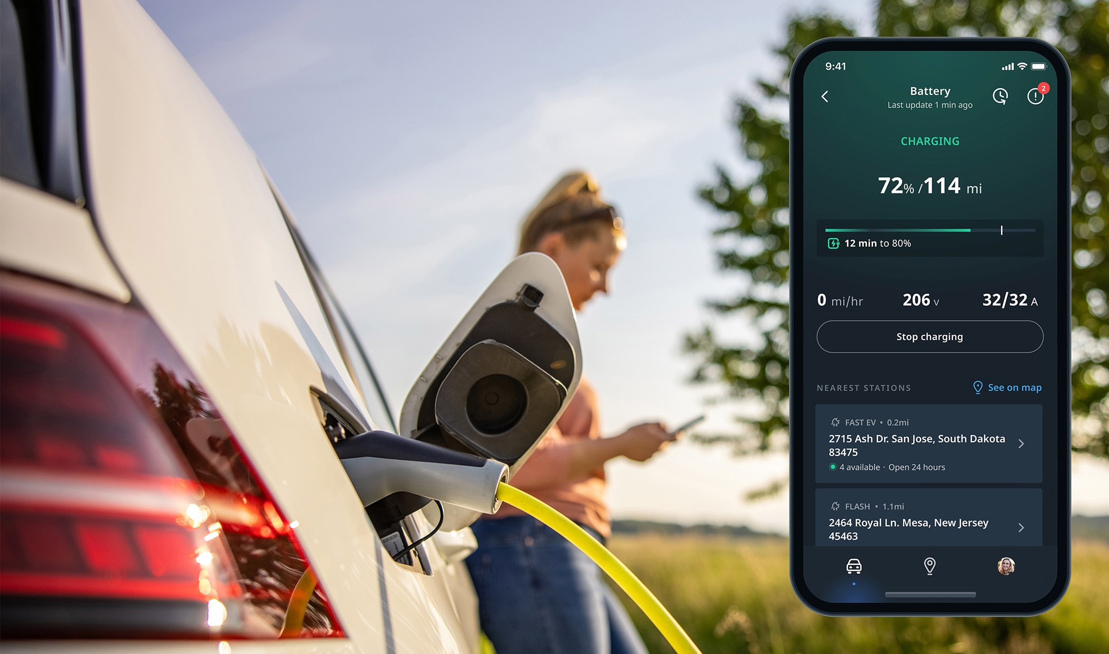
At the same time, aggregated mobility data provides insights into EV travel patterns and charging demand hotspots. These insights help charging operators and infrastructure planners deploy charging stations where they are needed most, accelerating the expansion of EV networks.
3. Building smarter, more sustainable road networks
Every transportation system depends on maps. TomTom’s robust maps and geospatial datasets provide a foundation for understanding how road networks function and how they evolve over time. Coupled with detailed traffic data, decision-makers get a clear picture into how congestion is impacting an area.
Detailed mapping and traffic data enables cities, urban planners and mobility providers to analyze road layouts, traffic flows and mobility patterns. These insights support better planning, infrastructure choices and policymaking.
With accurate geospatial data, planners can also model potential infrastructure changes — such as new roads, redesigned junctions or construction projects — to evaluate how they will affect traffic and emissions before they are implemented.
4. Turning traffic data into real, actionable mobility insights
To reduce transport emissions, it’s essential to understand where and why it occurs. Tools providing historical and real-time traffic data are key to revealing bottlenecks, peak congestion periods and changing travel patterns across a city.
Traffic analytics solutions — like the TomTom Traffic Index, Traffic Stats and Origin-Destination Analysis — help decision-makers understand how people move through the road network and how congestion affects travel time, economic productivity and emissions. For targeted insights and interventions, an Area Analytics tool enables authorities to analyze traffic patterns with any custom-defined zone, such as a city center or low-emissions area. 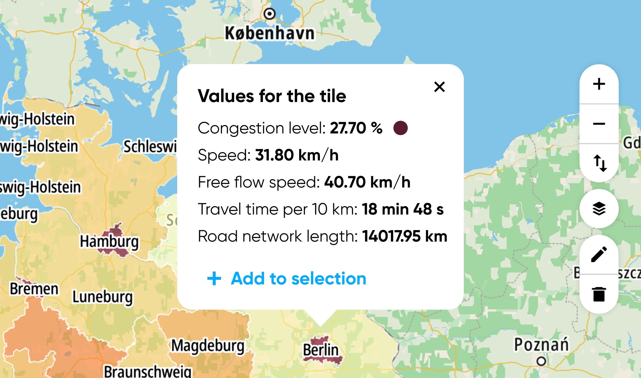 The TomTom MOVE platform brings these insights together, providing access to traffic analytics that support environmental impact assessments, infrastructure planning and cost-benefit analysis for mobility projects. These tools also enable scenario testing, allowing cities to evaluate how roadworks, infrastructure upgrades or traffic management measures might affect congestion and emissions before making changes on the ground.
5. Optimizing and managing traffic flow in real time
Alongside larger-scale, longer-term changes, it’s also important for cities to be able to make tweaks and manage traffic on the ground more effectively in real time. Using TomTom’s Route Monitoring and other analytics tools, authorities can adjust signal timing, manage lanes dynamically and introduce targeted traffic measures to keep vehicles moving more efficiently. These interventions reduce delays at bottlenecks and intersections, where idling and braking often lead to unnecessary emissions.
Tools like TomTom Junction Analytics provide even more granular analytics, help cities understand how vehicles are moving through complex intersections. This allows traffic engineers to optimize signal timing or redesign junction layouts to reduce congestion and improve flow.
The data-driven path toward low-carbon mobility
The right data and tools are essential to reducing transport emissions. Urban road networks involve millions of daily decisions — by drivers, planners, engineers and policymakers. Optimizing these networks for lower emissions requires insight and coordination that no single actor can generate alone.
TomTom provides a way to view transport networks like an MRI scan of the body — highlighting areas that need attention while providing trusted insight into the solution, able to pull up data past and present. This enables cities, planners and mobility providers to continually understand and optimize transport networks. Results also depend on cleaner vehicles, intelligent routing and EV adoption. 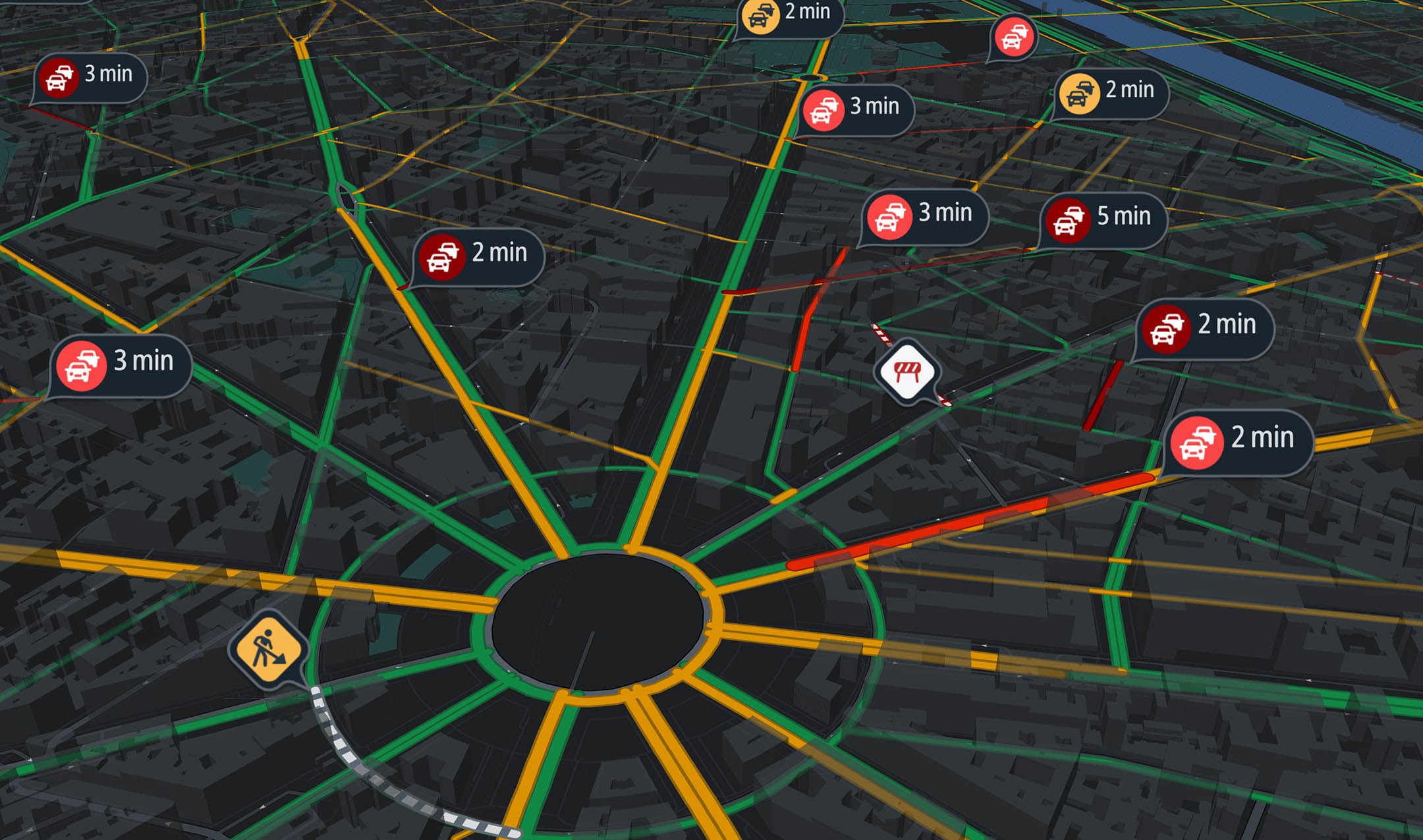 With its expanding toolbox, TomTom is helping its range of global customers, including automakers, cities and drivers, take informed action to accelerate a greener future through more sustainable mobility. For the transportation sector to meet its ambitious 25-year goal to reduce transport emissions by 50%, these data-driven tools will become even more essential to achieving efficient, resilient and sustainable transport.
On a final note
Next to the products and services, TomTom is walking the talk with its own operational goals to contribute to a greener future. The company has committed to achieving net-zero emissions across its value chain by 2040, with targets validated by the Science Based Target initiative (SBTi). The ambition builds on continuous efforts to reduce operational carbon footprints, integrate renewable energy across offices and drive sustainability throughout its supply chain.
As a data-driven company, TomTom is also focused on reducing data-related resource use. For example, by embracing open-source mapping in its strategy, the company is minimizing resource-intensive proprietary mapping, accelerating global updates and enabling broader adoption among its customers and partners. Another example is cloud usage. Through smarter engineering, workload optimization and a key partnership with Microsoft, TomTom is enhancing its cloud-based tech performance while reducing the environmental footprint of its services — on the journey to embed sustainability across all aspects of the business.
* Required field. By submitting your contact details to TomTom, you agree that we can contact you about marketing offers, newsletters, or to invite you to webinars and events. We could further personalize the content that you receive via cookies. You can unsubscribe at any time by the link included in our emails. Review our privacy policy. You can also browse our newsletter archive here.