)
As the world retreated from in-person shopping this year, mobility companies saw new peaks as everyone ordered everything imaginable, from home. Groceries, prescriptions, takeout and other necessities went mobile. Some even abandoned their regular public transit for the privacy of ridesharing.
This surge in demand has managers of on-demand applications searching for new ways to optimize the delivery process to retain all of these new users. At TomTom, we’ve been working hard to create development tools that help the on-demand space to strengthen their platforms during this delivery boom.
Finding places and faces, faster
Mobility and on-demand applications must account for many players and variables: drivers, third-party businesses, frequent stops with multiple customers and unpredictable road conditions. Add a large influx of new users, and it suddenly becomes even more stressful to manage.
With TomTom’s advanced Maps APIs, product managers of on-demand apps can accommodate new customers and keep them coming back to their application, knowing they’ll have a satisfying user experience supported by highly accurate location technology.
Let’s break down how TomTom technology helps on-demand application product managers to simplify short-range delivery.
Better search results
The first part of a user’s interaction with a given on-demand application is to search for a place – their destination, a restaurant, grocery store or another business which fits their needs.
The key to keeping the user’s interest at this early stage is to ensure they have access to the most accurate, relevant search results. This first crucial step is supported by our Search APIs Fuzzy Search – but there’s nothing fuzzy about it. The Search APIs job is to account for any typos or inaccuracies (e.g. “Maine St” should be “Main St”) in a user’s search query and work around them to still provide the most refined results.
Integrating our POI Index provides optimized information about businesses (points of interest) around each customer’s location at the tap of a finger. We continually curate and grow our POI partnerships, which allow us to add even more businesses for customers to connect with as they search.
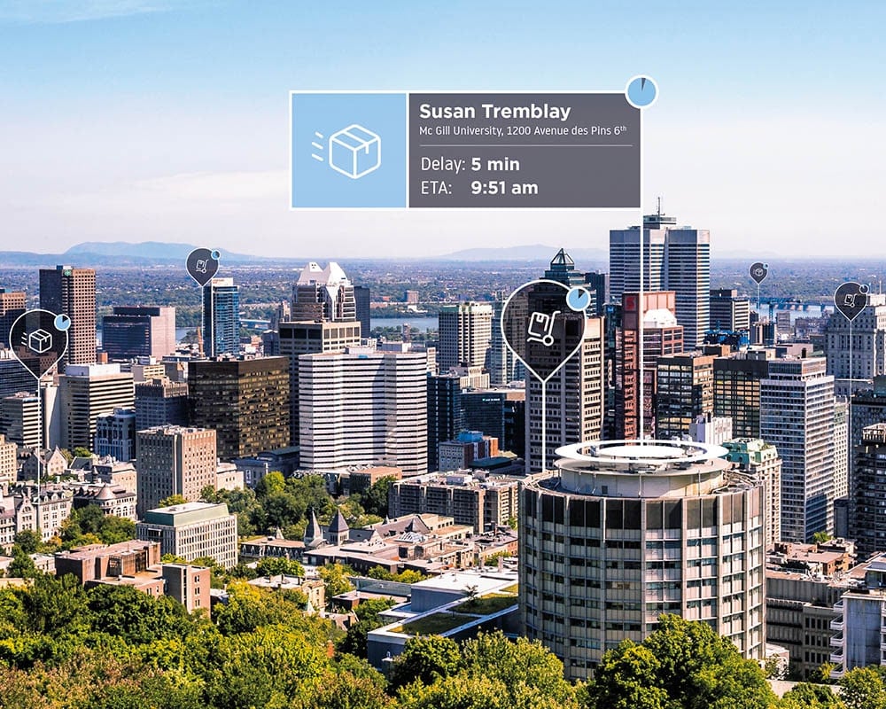
Scheduling with highly accurate ETAs
After the customer places an order, the first screen they usually see is a map, giving them visual reinforcement to the ETA they are shown within a few seconds of confirmation; the Map Display APIs is responsible for reinforcing this visual feedback. What is presented within a short time for the customer represents quite a bit of algorithmic heavy lifting, which we know as scheduling.
Different on-demand companies might tailor the algorithms which power this optimized matching in different ways. They might be tailored to have a specific bias in the interest of safety, speed, the use of public transit, or the shortest ride vs. the payout involved for a trip (such as the order total for takeout or groceries).
Within the same few seconds that a driver is matched to a customer’s order, a route is generated, accounting for several factors such as needed stops, traffic, and any other conditions specific to the app. This route, along with all the information about current road conditions, is what helps produce the all-important ETA estimation that the user sees on their screen.
Driving the route
As the user eagerly watches their map and ETA for their delivery or rideshare, a driver is hoping that their predetermined route will get them to their destination(s) as quickly and smoothly as possible.
With routes calculated using TomTom road data, drivers can feel secure knowing that their route was selected to best match the ETA given to their customer – meaning they’re less likely to be at risk for bad reviews or tension, as can happen when ETAs don’t match up.
When their route is first generated, a few different processes take place. The Routing APIs works in tandem with the Traffic APIs and Speed Profiles automatically, creating driving directions which avoid congested areas. Routes can usually be created with a simple A to B framework. For deliveries that include multiple stops, the routing engine can utilize Matrix Routing to find the best overall path between a set of locations.
Routes created in real-time use continually updated traffic information, while routes scheduled in the future (such as those with multiple stops) rely on heavily contributed, vetted historical traffic information. Speed Profiles use the same information to profile the average speeds at various times for given roads, helping the routing engine to decide the fastest possible route throughout the day.
Creating alerts for consistent updates
Utilizing the traffic layer within the Routing APIs helps bridge communication between the driver on a busy route and their waiting customer. By providing minute-to-minute updates, traffic prediction helps managers drive trendlines for peak commuting times, special events, and redirections from road hazards, all of which affect pickup and destination travel times for all drivers. Traffic incidents alone pulled from our Traffic APIs can help reinforce updates. Pairing them with the Notifications API enables an application to message a user with up-to-the-minute ETAs.
Geofencing technology works hand in hand with the Notifications API to optimize last-mile alerts when deliveries or drivers are close to a destination or pickup point. When a driver passes a specific location, it can be set to trigger a certain perimeter alert without the driver’s action. The Geofencing API allows perimeters to be set around destination points, indicating when a driver is close to arriving. Then, the Notifications API takes over to send alerts to the customer that their delivery or driver is approaching their location.
When a customer is finally picked up or their food is delivered, Reverse Geocoding combined with our advanced POI information translates latitude and longitude points into identifiable addresses, which include specific entry points for the address. This level of detail makes sure drivers are directed to the right side of the street and to the right doorway in a building—because no one likes when a driver has a hard time finding a delivery address, restaurant entrance or pickup point for rideshare.
By harnessing the power of these powerful routing resources combined, managers can ensure a smooth user experience, even during unpredicted incidents, heavy traffic, and popular delivery time windows. If users find an app reliable, they will continue to return to it for their ordering needs – which in turn will attract drivers seeking short waiting times between orders, so they can earn more per day of driving. Narrowing this waiting window keeps drivers driving more frequently with each app, increasing the bandwidth for meeting customer demand.
Moving mobility into the future
On-demand technology product managers have more to account for than ever, whether it’s updating their application or starting an entirely new project with a goal to connect the community in unpredictable times. Creating a strong foundation for both driver and user experiences is vital – not only to ensure that both keep choosing a given application again and again, but to show that anyone can harness advanced location intelligence to create innovative solutions for a mobile future.
People also read
)
How on-demand, mobility and logistics leaders make TomTom maps better
)
What is last mile delivery tracking?
)
How to optimize fleet routing and improve ETAs
* Required field. By submitting your contact details to TomTom, you agree that we can contact you about marketing offers, newsletters, or to invite you to webinars and events. We could further personalize the content that you receive via cookies. You can unsubscribe at any time by the link included in our emails. Review our privacy policy. You can also browse our newsletter archive here.