)
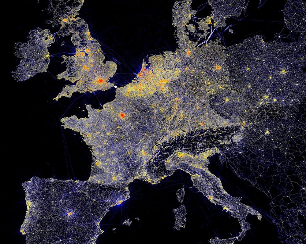
With 61 billion GPS data points collected each day, it is the hyper precision of TomTom data that enables us to create maps detailed enough that they can even be used to power safe autonomous driving.
Every year, a high volume of roads change. Speed limits are updated, businesses come and go, new streets are built and others are renamed. Reality is a roller coaster, and the challenge for mapmakers is to keep up with it. In order to deliver maps that reflect reality as accurately as possible, these changes need to be quickly processed. In this article, we’ll look at our map-making process to understand how we can consistently deliver accuracy down to centimeters to our customers.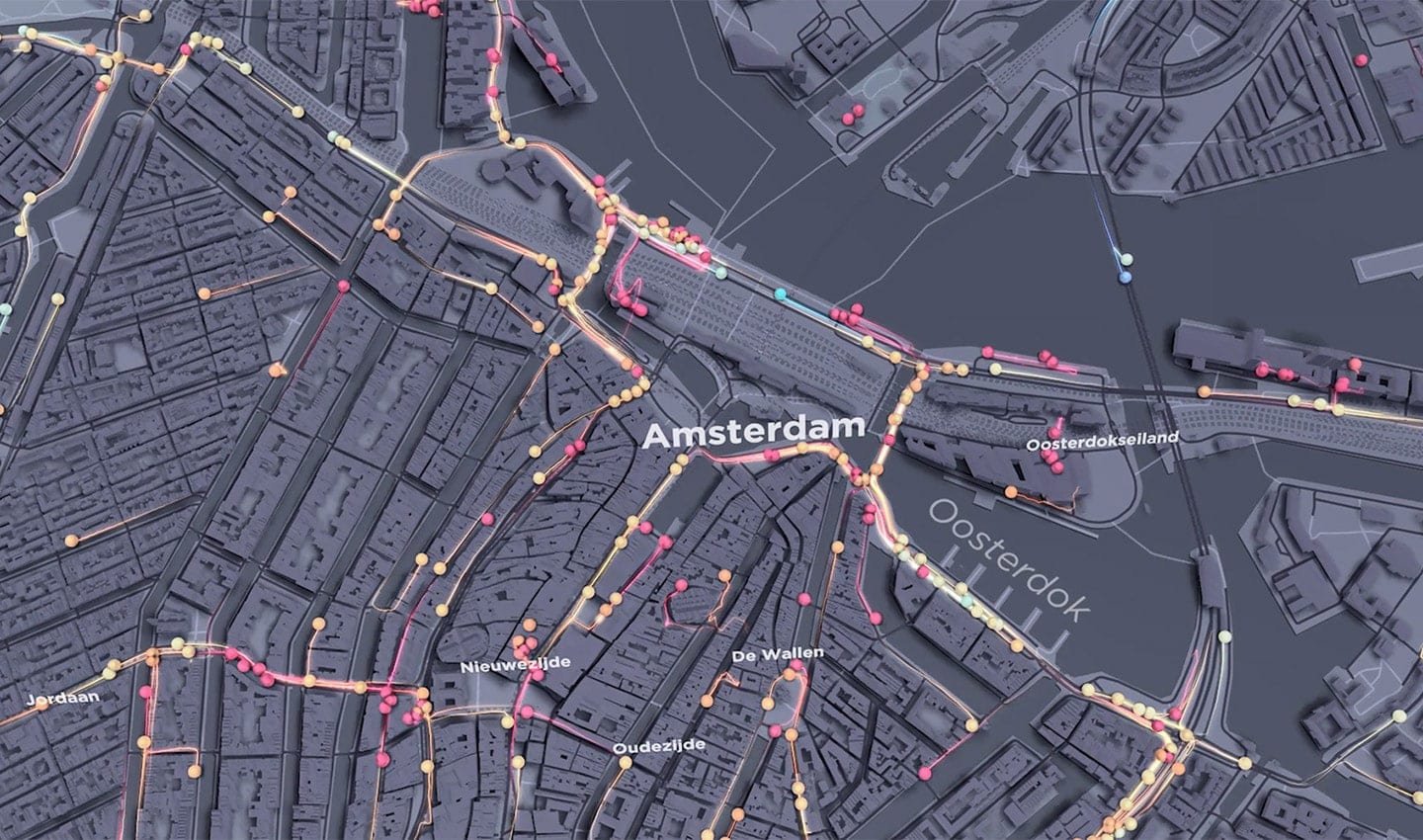
Visualizing TomTom probe data in Amsterdam
The formula
To achieve this, TomTom invented a continuously integrated map-making platform, able to deliver a continuously up-to-date map.
This platform enables us to quickly close the loop between the moment a change is detected in the real world to updating the map on a user’s device to a version that reflects this change.
How do we do this?
There isn’t one single method used for detecting change, but rather a combination of sources. Our multi-source approach combines data from survey vehicles, GPS traces, community input, governmental sources and vehicle sensor data to build our maps for maximum attribution, accuracy and maintenance levels, meaning their accuracy will not deteriorate over time.
For example, we work with local governments and road authorities to understand planned changes and use our global community of 600 million connected devices to detect changes that were perhaps unplanned. These changes are fused to ensure the most accurate reflection of reality.
Next, we select only the part of the map that is impacted by the change. We update the map and conduct a live quality check that assures accuracy. We then merge the changed piece back into the map as an incremental update. Because this quality assured process is transactional, the map database is continuously releasable.
Let’s go through each step:
Map users
The more users that use our technology on the road, the more accurate the driving experience. With almost a billion people using TomTom maps in devices around the world, drivers who choose to share map feedback with us help improve the quality of our data. Each month, we receive hundreds of thousands of consumer reports.
Sensor input
Whether from our own or partner devices, this data consists of billions of probe traces from 600 million connected devices every day.
Intelligent mapmaking
Through a combination of professional map-making methods and community input, we have perfected a hybrid approach that ensures both efficiency and accuracy through fast cycle times and quality assurance.
Data is received and processed to produce changes. We match probe-derived geometry daily against our maps, often referring to sources such as imagery to help with validation. Using community input also helps us to more smartly plan our mobile mapping van routes to achieve more in less time.
Transactional mapmaking
We process millions of real-world changes every week, this is done end to end, from detection to quality assurance. Users then receive incremental updates that are sent with a high accuracy-confidence and fast cycle times.
Continuously releasable map database
A continuously releasable database enables us to deliver the quickest updates to the user. Real-time quality assurance ensures that only trusted changes be incorporated into a database that is always globally complete and seamless.
Incremental map updates
Users get real-time and easy access to maps through several map delivery formats that are capable of incremental map updates for all features. MultiNet-R delivers all the high-quality content layers of the TomTom map database in a single, easy-to-use relational database model. As an industry leader in the adoption of the Navigation Data Standard (NDS), TomTom offers modular, plug-and-play runtime maps that are ready for use in NDS software applications. Our APIs provide streaming maps with total flexibility and access to the latest possible map changes.
Covering the world
Our maps move the world forward every day. They cover over 68 million kilometers of navigable roads in 164 countries and 35 territories.
More than three million kilometers are driven by mobile mapping vans each year.
Through our innovative, proprietary, transactional map-making platform, TomTom provides extremely accurate and up-to-date maps that enable our customers to make smarter mobility decisions every day.
Want to know more?
Read about our location mapping technology.
People also read
)
How to structure machine learning work effectively
)
The TomTom Traffic Index: An objective measure of urban traffic congestion
)
Measuring road traffic density: what you need to know
* Required field. By submitting your contact details to TomTom, you agree that we can contact you about marketing offers, newsletters, or to invite you to webinars and events. We could further personalize the content that you receive via cookies. You can unsubscribe at any time by the link included in our emails. Review our privacy policy. You can also browse our newsletter archive here.