)
As the task of driving gradually shifts from the driver to in-vehicle automated systems, the role and scope of digital maps shifts accordingly. This means that map users may no longer be drivers, but machines, and a new generation of maps – ADAS and HD – are here to support this new reality.
The future of driving is automated and, in order to support it, a mix of onboard sensors, smart algorithms, artificial intelligence and digital maps come into play.
For automated driving, digital maps complement car sensors. By using map data, the automated driving system can anticipate the road ahead, seeing far beyond the vehicle’s sensor range. The result is a vehicle capable of seeing around corners and adapting its driving behavior in poor visibility conditions such as rain or fog. Sensor fusion – combining inputs from different sensors with information from digital maps – makes automated driving safer, as the system can handle more extreme circumstances and adds redundancy.
From adaptive cruise control (ACC) to highway assist and autonomous driving (AD), they all benefit various levels of granularity provided by maps. The higher the level of vehicle autonomy, the more requirements digital maps must fulfill.
To fulfill these use cases, there are two types of specialized maps for assisted and automated driving: the ADAS Map and the higher accuracy, but lower coverage HD map.
What is the ADAS map?
Today, over one million automated vehicles on the road use the TomTom ADAS Map. These vehicles, sporting SAE’s Level 1 or Level 2 automation, are both private and commercial. They use the ADAS map for driver assistance and safety warnings, such as lane departure warnings, helping automakers get higher Euro NCAP ratings and drivers have a safer and more comfortable journey.
 The TomTom ADAS Map
How does the ADAS map achieve this? By providing the following road information to the vehicle:
Gradient
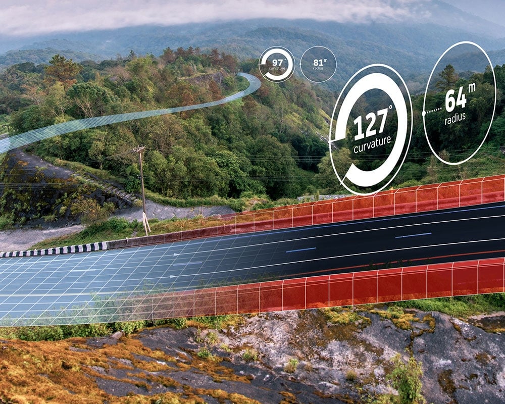
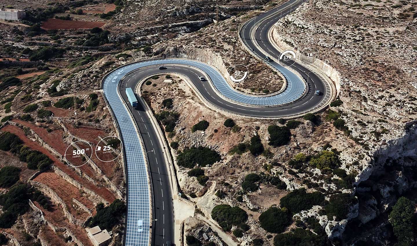
Indicates the steepness of the ascent or descent of the road.Curvature on road
Describes the positional accuracy – the sharpness – and direction of curves in the road.Traffic sign
Covers more than 20 types of traffic signs and their meaning, including sub-plates.Speed restriction
Indicates what is the maximum allowed speed for a road for a specific type of vehicle.Road curvature at junction
Describes the positional accuracy and direction of curves per lane at intersections.Lane at junction
Describes lane-level information such as direction and connectivity at intersections.
The value of road curvature at junction and lane at junction is that they give lane-level geometry values at roundabouts.
Next, we will examine how this is different in the case of the higher resolution HD map.
Download the TomTom ADAS Map product sheet.
What is the HD map?
When moving from assisted driving towards full autonomy – Levels 2, 3 and beyond – the HD map becomes the better solution for safe autonomous driving. While extremely accurate, ADAS maps reach their limit when more precision and detail are required.
 The TomTom HD Map
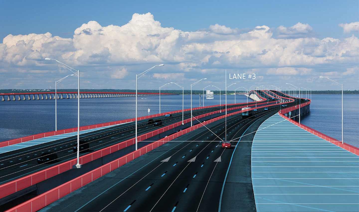
HD maps narrow this accuracy even further to resolutions of only a few centimeters while providing a higher degree of attribution. Using detailed information such as lane models, localization objects, lane-level speed restrictions, linear objects, traffic signs, road furniture and geometry per lane, HD maps enable automated and autonomous vehicles to become location-aware, environment-aware and path-aware.
As the first mapmaker to introduce HD maps – in 2015 – and the first one to offer HD map coverage across Europe, North America and Asia, TomTom is a trusted partner for carmakers pushing the boundaries of autonomous driving today – and in the future.
Download the TomTom HD Map product sheet.
What are the differences between the TomTom ADAS and HD Map?
Both the TomTom ADAS and HD Map improve automated driving and complement sensors. However, there are significant differences between them.
In essence, the ADAS map provides six attributes – listed above – with an accuracy of several meters. ADAS map data describes where traffic signs are located along the road and what their meaning is. Is it a stop sign, or a speed limit, or a traffic light? The ADAS map will identify it and its location along a road stretch. However, due to the way the underlying road geometry is modelled, the exact sign is located with a margin of error of meters.
For the HD map, a few meters turn into a few centimeters. The HD map describes almost everything on the road with centimeter-level accuracy. Taking the example of the traffic sign, the HD map knows its exact location as well as the size of the sign, position relative to the road (left, above, right), color, category, sub-category and text.
Another example are road barriers. While the ADAS map simply indicates the presence of a divider or not, the HD map also indicates the type of divider, its height, position and width. These additional attributes in the HD map are an example of input for centimeter-level localization, going far beyond the accuracy of GPS.
This highly accurate data allows for several new use cases for the HD map:
Aiding sensor perception for autonomous driving
A key challenge that comes with relying purely on vehicle sensors for environment perception is that even though sensors typically do a good job at capturing the environment around the vehicle, they struggle with putting the various elements into the right context.
For example, an HD map knows the exact location of all traffic lights at an intersection. While the onboard camera alone may focus on the wrong object, the HD map provides context to the observations made by sensors. In effect, the automated driving system will wait until the relevant light turns green and accelerate appropriately. Without an HD map, the car could focus on the wrong traffic light, misinterpret the changing traffic light signal or make an illegal maneuver by driving through a red traffic light.
A camera might detect a speed limit sign in its field of vision, but that sign could belong to an adjacent road instead and should be disregarded. HD maps help address this challenge by providing the much-needed context to the elements captured by sensors, enabling the vehicle to build a reliable and robust model of its surrounding environment.
By using HD map, the vehicle knows what road it is traveling on, and its corresponding speed limit, without being misled by speed limit signs in adjacent roads.Highly accurate vehicle localization for autonomous driving
Without localization, autonomous vehicles can’t plan smooth paths and safely reach their destinations.
Today’s navigation systems mainly use GPS for localization; however, GPS alone fails to provide the necessary level of accuracy and reliability. To address this challenge, TomTom developed RoadDNA, a set of layers in the TomTom HD Map that enables accurate and precise localization for autonomous vehicles supporting a variety of sensor architectures.
To precisely position itself, an autonomous vehicle aligns RoadDNA data with the data obtained by its sensors in real-time, resulting in a highly precise lateral and longitudinal position.
The TomTom RoadDNA suite is expanding to include the following:
RoadDNA-Signs
A collection of HD traffic signs along the road that works best with camera sensors.RoadDNA-RoadSide
A highly optimized lidar point cloud of roadside patterns. Roadside is the original RoadDNA – patented already in 2009 – and works best with lidar.RoadDNA-Markings
A model of individual lane markings along the roadway, which works best with camera.RoadDNA-Paintings
Horizontal signs on the surface of the road containing a bounding box, category, subcategory and value.RoadDNA-Radar
Radar layer to localize the vehicle using radar sensors.
Path planning for autonomous driving
As automakers develop systems with higher levels of automation, path planning becomes more and more important. This is because an automated vehicle needs to be able to plan its path at a very granular level in order to plot maneuvers across lanes in a safe and comfortable way. This is crucial for building trust with consumers.
Relying on vehicle sensors alone means having to perform path planning with a short horizon, limited to the sensors range. This can lead to inefficient or unsafe path planning.
For example, as the vehicle travels on the fastest lane on the highway, it might have to quickly cut across a few lanes to take the upcoming exit to reach its destination. This puts the driver and passengers in a dangerous situation. With path planning enabled by HD maps, the car can anticipate such a maneuver in a safe and timely manner.
On the road to autonomous driving
The future of driving is automated, and the TomTom ADAS and HD Map are there to support carmakers in making this future a reality today. Whether meters or centimeters, use the right map for the accuracy level your self-driving car needs.
People also read
)
What is adaptive cruise control and how does it work?
)
How ADAS helps truck drivers stay safe and drive efficiently
)
Behind the map: how we keep our maps up to date
* Required field. By submitting your contact details to TomTom, you agree that we can contact you about marketing offers, newsletters, or to invite you to webinars and events. We could further personalize the content that you receive via cookies. You can unsubscribe at any time by the link included in our emails. Review our privacy policy. You can also browse our newsletter archive here.