)
Maps are a special technology. For centuries they’ve helped us understand our changing world and solve ever-evolving challenges such as how to get from a to b, how to design cities and how to manage traffic, among others. Recently, we interviewed Johan Land, TomTom’s Chief Product Officer, to learn more about maps’ unique ability to positively contribute to road safety.
Watch Johan Land explain how maps are playing a unique role in helping improve road safety

The state of road safety
“If you look at people’s lives and the risks they’re exposed to, road safety is one of the most serious,” Land says.
Road safety is one of the world’s major health and development challenges. According to the World Health Organization (WHO) and its Global Status Report on Road Safety 2023, there were an estimated 1.19 million deaths last year — a slight decrease from 1.25 million in 2010. That might not sound like much but consider that there are 1 billion more people on the planet, twice the number of vehicles and road networks have expanded dramatically. There’s still a long way to go, but technology and initiatives to reduce road fatalities and increase safety are working.
How maps contribute to road safety: Intelligent Speed Assistance
While vehicles themselves are a major source of risk on the road, they are also helping make roads safer through data, Land explains.
Today, TomTom gets consistent insights into more than 85 million kilometers of roads every day. “This is telling us what is happening on the roads, where traffic is moving, has something happened, what’s the weather like, is something standing still on the road. And we get all of this in real time giving us an enormous opportunity to create good solutions for road safety.”
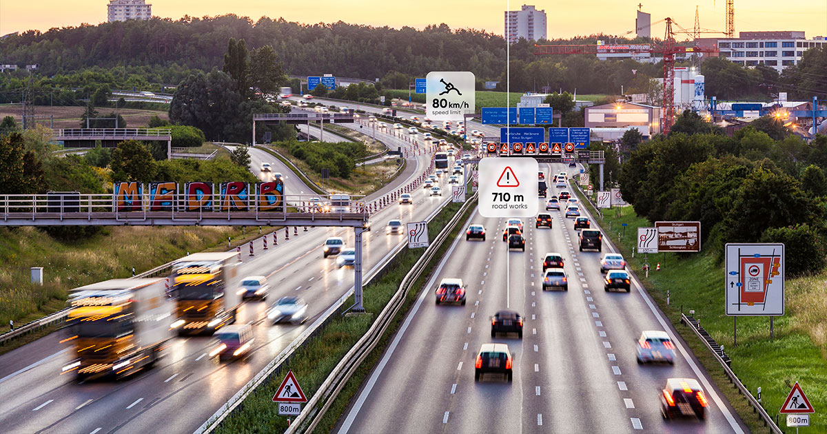
Intelligent Speed Assistance (ISA) is a great example. ISA is a technology that informs drivers of the current speed limit to ensure they stay within the safe and legal boundary. In Europe, it’s a legislative requirement that all new vehicles come with a form of ISA that meets the required accuracy threshold of being correct 90% of the time. ISA is also a great example of how maps and real-time data are required alongside on-vehicle sensors to deliver a high level ADAS (advanced driver assistance system).
“Sensors have certain physical limitations, they will never be able to do certain things, like seeing around a corner or seeing through a truck. Sensors also can’t see through types of sun glare,” Land says.
“There are also limitations such as not being able to identify what a sign says through just one camera image.” Addressing these challenges, and the specific limitations of camera-based sensors is where maps come in.
If you drive past an obscured sign once, as a sensor, the likelihood of interpreting it correctly is quite low, but get 100 people to drive by and capture it and the accuracy of the observation increases dramatically. Make another 100 people drive by and the accuracy of the observation increases further still.
“With our map, [TomTom Orbis Maps] we can be more accurate on exactly what a sign says than a sensor because we’re not just observing it once, we’ve seen that sign thousands of times. With a high degree of accuracy, we can say what that sign is for sure, we can also say if we don’t see a sign allowing us to spot omissions of data accurately.” Land explains.
What maps need to contribute to road safety
Indeed, accuracy is incredibly important when it comes to spotting and relaying speed limits to drivers. Freshness and coverage are also crucial, Land says. If you get these three things wrong, you won’t be able to achieve safety. Delivering a map that’s fresh, accurate and has broad coverage is the perennial challenge for mapmakers, and according to Land, it has only gotten harder over time.
“The map 20 years ago was simple, it described roads that went from one city to the next city. But now, a map has so much more detail there, detail which can help improve road safety, but it makes the problem harder.”
“Things like where are the lanes, what are the driving restrictions, what’s the speed limit, is there a traffic jam, are there roadworks, are all details and data that we need in order to contribute to road safety in the way we want to,” he adds.
The future of mapping and making roads safer
The need for more data, more accuracy and freshness, is one of the drivers motivating TomTom’s new map, TomTom Orbis Maps. “We believe the best way of solving this harder problem is to enter a new era of collaborative mapmaking,” Land says.
“This is where we work with our closest partners to create a much better map, a much richer map, a more accurate map that has more coverage — starting this with three of our key partners, Meta, Amazon and Microsoft.” This has recently extended to include nearly 30 partners, all of whom are contributing data and working on an agreed and collective standard which governs how the data is shared.
With this standardization, “data can easily be shared, conflated and combined. We [TomTom] quality check it and validate it to be sure that we have the coverage, accuracy and freshness for safety and other applications.”
Indeed, thanks to this collaborative approach, “we have access to an enormous amount of data, we have hundreds of millions of devices that give us information about how people and things move around in the world," Land adds. This abundance of real-time data empowers TomTom to develop innovative solutions that enhance road safety.
Land concludes: “Road safety is truly something that sits deep within our DNA at TomTom, and it’s one of the ways in which we can truly make a difference with our map. With all our capabilities, and tech we’re building, it’s a duty we have.”
People also read
)
The latest: What you need to know about intelligent speed assistant regulations
)
How routing algorithms prioritize safety over speed in rural Finland
)
Helping drivers 'see' further with Jam Tail Warnings
)
A brief history of the cruise control system in your car
* Required field. By submitting your contact details to TomTom, you agree that we can contact you about marketing offers, newsletters, or to invite you to webinars and events. We could further personalize the content that you receive via cookies. You can unsubscribe at any time by the link included in our emails. Review our privacy policy. You can also browse our newsletter archive here.